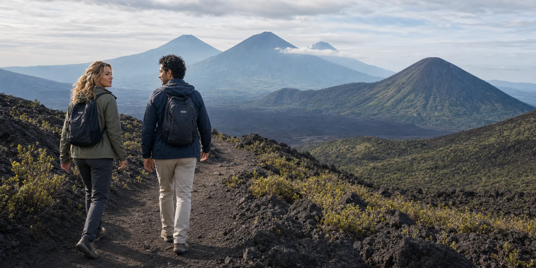
Pacaya does not need an eruption to feel alive. The black ground can be rough enough to slow every footstep; vegetation stops abruptly where younger lava has reset the slope; MacKenney cone rises from a much older volcanic complex; and the horizon can place Agua, Acatenango and Fuego in the same visual argument. The scene is legible only when the superlatives are stripped away. Dark rock is not necessarily recent. White vapor is not a promise of harmless steam. A quiet seismic trace is not an all-clear for every part of the mountain. “The summit” is not an honest shorthand for whatever point a visitor reaches.
INSIVUMEH’s daily bulletins deliberately separate observation from advice. A report may describe seismicity, degassing, rain or wind while its recommendations define places that visitors should avoid. Those are different kinds of information: the observation says what instruments and observers recorded, while the access decision says where a person may responsibly go. Neither should be stretched into a permanent promise.
The practical consequence is simple: Pacaya is a route decision, not a volcano tick-box. Before committing to a departure from Antigua, a traveler needs the exact authorized entrance, the day’s turnaround, the surfaces underfoot, the guide and operator registrations, the response to the newest bulletin, and a plan for anyone who cannot walk the whole uneven sequence. The official bulletin and the park administration—not an old track or a marketed ritual—define the usable line.
01 · Pacaya field guide
First, locate the mountain correctly
Pacaya belongs to the Central American Volcanic Arc, a chain created above the boundary where the Cocos plate descends beneath the Caribbean plate. “Friction melts the crust” is an appealing shortcut and a poor explanation. Water and other volatiles released from the descending slab change the conditions in the overlying mantle, encouraging melting; magma then rises, stalls, mixes and sometimes reaches the surface. The arc is a regional system, but each cone has its own plumbing, rock history and hazards.
The name Pacaya also covers more than one neat cone. The Smithsonian Institution’s Global Volcanism Program classifies it as a composite and complex volcano. The active MacKenney cone sits inside a broad arcuate scar left by a flank collapse roughly 600 to 1,600 years ago. Older cones and domes occupy the larger complex, which lies along the southern fault zone of the Amatitlán caldera. A 2026 petrological study describes Pacaya’s modern cone as basaltic and explains how activity renewed in 1961 after a prolonged quiet interval. Six decades of intermittent lava and tephra then built MacKenney to about 2,569 meters in the Smithsonian profile; INSIVUMEH’s operational bulletin uses 2,552 meters. The small difference is a reminder to name the source and purpose of an elevation rather than turning it into false precision.

The broader protected area includes the volcano and Laguna de Calderas. Guatemala’s protected-area tourism portal places the visitor center at the road fork between San Vicente Pacaya and San Francisco de Sales and describes Cerro Chino, El Inactivo and MacKenney among the complex’s cones. The park was declared in 1963. Its meaning is therefore double: it protects a changing geological landscape, and it channels visitors through a landscape in which people live, farm, guide, sell services, monitor risk and plan evacuations.
Seen from the trail, this scale helps separate the visible parts. MacKenney is the modern active cone, not the entire massif. A dark plain can be a succession of overlapping flows rather than a single event. A curved ridge can belong to the older collapse architecture. Distant Agua, Acatenango and Fuego are other volcanoes, not extra summits of Pacaya. On a cloudy day, none of those relationships becomes less real; only the view becomes less complete.

02 · Pacaya field guide
The route from Antigua has two different stories
The first story is the road transfer. Departures sold from Antigua add a vehicle and handoff to a park visit that can also be arranged closer to Pacaya. Guatemala’s protected-area portal estimates about an hour by road from Guatemala City via CA-9 and locates the visitor center at the San Vicente Pacaya–San Francisco de Sales fork. Antigua uses a different approach before joining the Pacaya road network, so no city-to-park estimate should be treated as a promise. The exact meeting point, vehicle, entrance and responsibility for delays belong in the booking confirmation.
The second story is the foot route. Pacaya has several approaches, and volcanic advice, weather, erosion and park management can change which line is available and where it turns around. A useful itinerary therefore names the trail, distance, cumulative ascent, surface sequence and stopping point. “Easy to moderate,” “lava field” or “summit area” cannot replace that profile, and a route downloaded from an earlier visit is evidence of someone’s past movement, not permission for today.
An older Ministry of Culture information page describes three approaches. Its San Francisco de Sales route climbs about two kilometers through forest to La Meseta, then describes another kilometer toward the upper cone. It also names Vuelta de la Corona near El Cedro and a southern approach via Patrocinio and El Rodeo. Those details are useful history and orientation, but they cannot establish the current authorized trail. The same page uses summit language that should never override a newer bulletin or an instruction from the park administration.
The route should therefore be read as a chain of gates:
- Meet at the named Antigua departure point rather than assuming a hotel pickup.
- Confirm the day’s vehicle, driver, group size and transfer plan.
- At the park, identify the actual visitor center or authorized entrance and the registered guide who takes responsibility for the mountain section.
- Name the current trail and turnaround in words that can be checked against the official bulletin.
- Treat any lava, fissure, vent or degassing area as conditional, never as an entitlement purchased with the tour.
- Return by the same authorized system unless the guide and park explicitly approve a different route.

This chain is more useful than a single duration claim. Ask whether the quoted time describes the whole outing or only the walk, and how much of it is spent in the vehicle, at the entrance, moving uphill, resting and descending. A route can feel moderate to a regular hill walker and severe to someone unaccustomed to loose ash, angular lava, heat, sun or repeated ascent. Difficulty is not a single adjective; it is the combination of gradient, footing, elevation, weather, pace, exposure and the quality of the turnaround decision.
03 · Pacaya field guide
What the black ground can and cannot tell you
Basaltic volcanoes can produce lava that behaves in markedly different ways. Smooth or ropy pāhoehoe forms when a relatively fluid surface can continue to deform. Rough, clinkery ‘a‘ā breaks into unstable fragments as it moves. Pacaya has produced both, with ‘a‘ā more common in its modern history. Once cooled, either can remain sharp, hollow, fractured and mechanically unreliable. A black surface does not reveal its temperature at depth; a crust can bridge a void; a flow margin can shed blocks; a fissure can be hidden by later rubble.
The popular marshmallow ritual compresses all of that into a photograph. It also encourages a misleading explanation: that rainwater is always being superheated by a magma chamber just below the visitor’s hand. Warm air at a lava field can have several pathways, including heat retained in rock, circulation of air through fractures and volcanic gas. A “steam vent” should not be named by smell or appearance alone. Water vapor is invisible; the white plume people see is condensed droplets, and volcanic emissions may include carbon dioxide, sulfur dioxide, hydrogen sulfide and other gases. Concentrations vary with source, wind, topography and distance. Smell is not a measuring instrument, and the absence of smell is not proof of clean air.
Measurements made during the 2021 flank eruption show why appearance is such a weak guide. In research published in 2026, scientists compared gas at the central crater and at the flank fissure. The fissure plume contained much more water vapor relative to sulfur dioxide, and less carbon dioxide relative to sulfur dioxide, than the central plume. They inferred that partly degassed magma had branched into a lateral pathway and that groundwater interaction also altered the gases. The visible activity still looked like lava spattering and effusion. That is an explanation of one eruption’s plumbing, not an analysis of the opening beside a visitor’s foot: neither a white plume nor a roasting demonstration establishes what is being breathed.
Marshmallow roasting is widely marketed around Pacaya, but it is not an entitlement to a hot opening or a specific lava field. The only responsible version is one in which the park and authorized guide designate the place after checking the bulletin and ground conditions, keep the group off unstable crust and omit the ritual when the location is not approved. A traveler should never step away from the guide to find “more heat.”
Good trail reading is deliberately less dramatic. Place the entire sole on stable ground. Shorten the stride on loose cinder. Leave space so one person’s slip does not collect another. Do not use a fumarole rim or hollow crust as a handhold. Watch the return surface as carefully as the ascent; loose descents produce many falls because gravity and fatigue align. If the wind brings irritation, coughing, headache, dizziness or nausea, move upwind and away under the guide’s direction rather than waiting for a photograph.
04 · Pacaya field guide
Pacaya’s recent history is a sequence, not a single personality
Calling Pacaya “Strombolian” is a useful beginning and a bad ending. Strombolian activity describes discrete bursts caused by gas accumulating and escaping through relatively fluid magma, often throwing incandescent material around a vent. Pacaya has also produced lava fountains, ash columns, lava flows from summit and flank vents, ballistic projectiles, fires, road blockages and flank movement. Its normal-looking degassing can coexist with hazards that are highly local. Its history shows that the location of a vent matters as much as the label attached to an eruption.
The modern sequence begins in 1961, when intermittent activity resumed after a long repose and a new cone grew inside the old collapse scarp. That activity did not proceed at one constant rate. It alternated among quieter intervals, explosions and effusion. The lesson for a visitor is not that the volcano has been “erupting for sixty years” in a uniform way. It is that today’s cone is young, constructed by episodes, and capable of changing both its surface and its preferred outlets.
The eruption of 27–28 May 2010 is the essential human marker. A VEI 3 event produced heavy tephra fall, damaged or destroyed hundreds of homes, injured dozens and killed a journalist. More than 2,500 people evacuated. Ash reached Guatemala City and disrupted transport. Field work in nearby San Francisco de Sales documented impacts on roofs, crops, infrastructure and everyday movement. The event is not a suspense anecdote for a hiking article; it explains why residents’ trust, past experience, household responsibilities and belief in official messages shape evacuation decisions.
The 2010 crisis also exposed a false binary in disaster storytelling. Staying is not always simple ignorance, and leaving is not simply obedience. A door-to-door survey conducted in the Pacaya region in 2016 found that past evacuation behavior was strongly associated with hazard exposure, hazard perception and perceived readiness. Future intention was also influenced by previous evacuation, perceived home vulnerability and warning messages. Risk communication works through relationships and feasible choices, not through the assumption that everyone hears one siren and responds identically.
In 2014, eruptive activity again coincided with measurable deformation and southwest-flank movement. Radar studies of 2010 and 2014 found transient flank-instability episodes that decayed for years. This does not mean a hiker can see a whole flank moving. It means the symmetrical-cone image is incomplete: Pacaya’s southwest sector has structural behavior that researchers examine across long time series.
The 2015–2021 eruptive period culminated in Pacaya’s most consequential recent phase. In early 2021, explosions and lava effusion intensified. Ash fell in numerous communities; lava moved down several flanks, burned vegetation and crops, obstructed roads and approached homes; ash closed La Aurora International Airport. A flow that began in late April exceeded two kilometers before effusion stopped in mid-May. The Smithsonian’s record lists the last known eruption as 2021, while later official reports continue to describe fumaroles and degassing. “Last eruption 2021” therefore does not mean “dead since 2021.” It distinguishes eruptive output from continuing monitored volcanic activity.
A 2026 study of the 2021 products adds the hidden chronology. Crystal chemistry indicates a deeper magmatic environment around four kilometers below the summit and a shallower one around one to two kilometers. The researchers found evidence for recharge and mixing from December 2020 into January 2021, then another phase coinciding with the most intense activity in late February and March. Those are reconstructions from erupted crystals, not a tourist warning clock. They explain how magma that later erupted was assembled; they do not license anyone to promise weeks of warning before every future change.

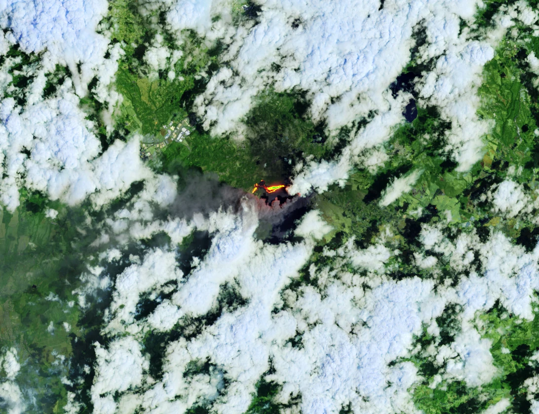
The satellite view makes the scale of that episode easier to grasp. The bright trace is a heat signature selected by the image’s band combination, not a highlighted walking route. Green ground surrounds the volcanic surface, and cloud interrupts the view. The image records a particular day in 2021; it cannot show whether a path is open on a later visit. Read together with the eruption history, it helps explain why the mountain cannot be divided neatly into a visitor attraction on one side and an inhabited, cultivated landscape on the other.
05 · Pacaya field guide
Monitoring is evidence, not an invisible force field
INSIVUMEH combines field observations and instruments; CONRED coordinates risk reduction and public recommendations with institutions and local structures. Seismic stations listen for different kinds of ground motion. Cameras and observers track visible changes. Satellite radar can measure ground displacement over broad areas. Thermal sensors can detect heat at the surface. Gas observations can add information about degassing. Rain and cloud can complicate several of those signals.
The important word is combine. No instrument turns a volcano into a machine with a countdown display. A 2024 study of the 2021 eruption used nine radar datasets from five satellite platforms and seismic data from four permanent stations. Radar results were compatible with downward and westward movement on the southwest flank, but lava compaction and atmospheric water vapor may have contributed to the signal. Seismic amplitude peaks appeared to follow the vigor of lava effusion, yet gaps prevented researchers from determining whether recognizable signals preceded every change in behavior. One-station noise correlations captured rainfall variability but were otherwise too noisy for clear volcanic conclusions.
That is good science precisely because it states the limits. Monitoring can detect patterns, test models and support decisions; it does not guarantee that every dangerous process supplies a long, clean warning. Ballistic material near a vent, a collapsing crust, a falling block, a gas pocket and a slip on loose cinder operate at different spatial and temporal scales. A tour can be consistent with a regional bulletin and still need a local turnaround.

For a visitor, the monitoring system becomes actionable through three layers:
- Before departure: read the latest INSIVUMEH daily bulletin, then ask the operator which route and restriction it implies.
- At the park: follow the park administration and registered guide, who can account for closures, weather and the actual ground.
- On the trail: respond to new instructions and symptoms immediately. A guide’s decision to shorten or cancel is the safety service working, not the product failing.
Official bulletins sometimes describe behavior as within the volcano’s normal parameters while still advising people to avoid active craters or flanks. “Normal” means comparison with a monitored baseline. It does not mean every location is harmless or every advertised activity is available.
06 · Pacaya field guide
The mountain is also a workplace
An Antigua day trip can make Pacaya look like empty terrain waiting for visitors. It is not. San Vicente Pacaya, San Francisco de Sales, El Cedro, El Patrocinio, El Rodeo and other settlements occupy a landscape linked by roads, farms, water, family networks and volcanic risk. The municipal development plan identifies tourism as a source of jobs and a development opportunity, but it also treats evacuation routes, contingency planning and institutional coordination as necessary public infrastructure.
The park’s administrative history reflects this shared landscape. The 2019 municipal plan describes co-administration involving the municipality, the National Forest Institute (INAB) and the National Council for Protected Areas (CONAP), with INAB as principal administrator at that time. The current protected-area tourism portal still names INAB as administrator and provides park contact numbers. INGUAT describes a Pacaya working table made up of the municipality and park administration. These overlapping roles are not trivia: they explain why a commercial operator alone cannot define an authorized route.
Local guiding is another layer. INGUAT publishes a community-guide registry with entries associated with San Vicente Pacaya and the national park. A government report from December 2025 described identified guides, marked routes and park protocols. CONAP’s responsible-tourism guidance tells organized groups to ensure that operators and guides are registered with INGUAT and authorized by the protected-area administration. A visitor should therefore ask for both parts: national tourism registration and permission to operate on the route that day.

Services around the park distribute some visitor spending locally. Official cultural information lists a community café, community parking, local guides, horse service and a picnic area near La Meseta. Those services deserve neither romantic inflation nor dismissal. A guide is a paid professional, not picturesque scenery. A horse is working infrastructure with welfare and rider-fit questions, not an automatic rescue plan. A picnic is food logistics, with allergy, water and waste implications. The most respectful purchase is the one whose money chain and responsibilities can be named.
The municipality contains distinct settlement histories. Its development plan describes an agricultural micro-region with a high proportion of Indigenous residents, including people displaced by the armed conflict who lived in Mexico and returned after the peace accords. It places Nuevo México within that region. This is a specific account of displacement and return, not a label for every settlement around the volcano. San Francisco de Sales, El Cedro and other guide communities should be named in their own right; a visitor’s assumption that every local guide is Maya cannot establish a person’s identity. Ask how people wish to be identified, and treat knowledge of the mountain as professional expertise rather than proof of an ethnicity.
07 · Pacaya field guide
A protected volcanic landscape recovers in patches
Fresh lava erases above-ground vegetation along its path, but it does not create a permanently sterile world. Cooling, fracturing and weathering begin to produce surfaces that organisms can occupy. Wind and animals move spores and seeds. Lichens, mosses, herbs and shrubs establish where temperature, moisture, shelter and substrate allow. Roots and organic material help trap finer particles. Forest survives or returns on older, more stable ground. The result around Pacaya is a mosaic: dark young flows, older colonized lava, shrub zones, forest and cultivated land at different distances from recent disturbance.
The mosaic matters for both ecology and route design. A trail that concentrates feet can protect a larger surface from trampling, but heavy use can widen the corridor, loosen cinder, cut switchbacks and leave waste. Walking on a younger flow may seem environmentally harmless because little vegetation is visible, yet it can crush pioneer growth, destabilize brittle features and carry people into a hazard zone. Conservation and personal safety often point in the same direction: stay on the approved line.
The park also protects more than MacKenney. Laguna de Calderas and older landforms broaden the ecological and hydrological story. The municipal plan calls the lagoon an important local water source and treats forest cover, protected land, agriculture and low-impact tourism as parts of territorial planning. A volcano visit that regards every green patch as backdrop misses the resource relationships underneath it.
Do not collect lava. The impulse seems harmless because the ground appears abundant, but a protected area is not a souvenir quarry, and repeated removal is cumulative. Do not feed animals, carve rock, leave food scraps or abandon marshmallow sticks. Carry out everything brought in. If a picnic is part of the day, ask how organic waste, packaging and reusable service are handled before the group reaches the trail.

08 · Pacaya field guide
What “moderate” feels like on Pacaya
No universal rating can substitute for a route profile, but the physical demands can be separated.
Altitude: MacKenney’s summit elevation is above 2,500 meters, though a lawful tourist turnaround should be lower than the crater. A day transfer from Antigua still raises the body quickly. Many healthy visitors will notice only faster breathing; some will develop headache, nausea, dizziness or unusual fatigue. Altitude is not the only explanation for those symptoms—heat, dehydration, gas, anxiety and illness can overlap—so the correct response is to report them and stop rather than diagnose oneself while walking. Do not continue higher while unwell. Worsening symptoms require descent and medical assessment, not an argument about completing the itinerary.
Surface: Forest soil, loose ash, cinder and angular lava behave differently. Fine material can slide under the shoe on descent. Coarse clinker can catch a toe. A hollow or fractured crust can fail. Trekking poles may help balance on ordinary trail but should never be used to probe or cross an unapproved flow.
Gradient and pace: A short steep segment can dominate the effort. The historic San Francisco de Sales description gives two kilometers to La Meseta, but it is not proof that a particular departure uses that line. Ask for cumulative gain and the slowest planned pace. A small group is only an advantage if the guide genuinely adjusts rather than pulling everyone toward one timetable.
Weather: Pacaya’s high exposed ground can move between sun, wind, cloud and rain. In the wet season, rain changes traction and can hide views; year-round, ultraviolet exposure matters at elevation. A measurement in a volcanic bulletin describes one reporting period, not the next hike, so use the actual forecast and the park’s day-of-travel judgment.
Return reserve: Reaching the viewpoint is only half the walking. The group needs energy, water and daylight for the descent and transfer. A good turnaround occurs before the weakest walker empties that reserve.
Preparation follows from those variables: closed shoes with a grippy sole; water; sun protection; a breathable layer plus wind or rain protection; essential medication; and a small pack that leaves hands free. Fashion sneakers can be comfortable on pavement and insecure on cinder. New heavy boots can create their own problem. The best footwear is familiar, stable and appropriate to rough ground.
09 · Pacaya field guide
Gas, heat and weather require different decisions
Travel advice often collapses every discomfort into “volcano conditions.” It is more useful to distinguish the trigger.
If gas or aerosol causes eye or throat irritation, coughing, chest tightness, headache, dizziness or nausea, tell the guide immediately and move upwind and away from the plume. People with asthma, chronic lung or heart disease, pregnancy or other relevant conditions should obtain individualized medical advice before booking and disclose decision-relevant needs to the operator. A generic product page cannot clear someone medically. Serious or worsening symptoms need medical help through the local response plan.
If heat is the issue—hot air from a fracture, hot ground, a warming shoe or unexpectedly hot rock—back away along the known route. Do not test with a hand. Do not pour water into an opening. Do not crowd around a single heat source. The absence of glowing lava says nothing about temperature below a crust.
If weather changes, the response depends on the change. Lightning means leaving exposed high ground under the guide’s plan, not sheltering beneath an isolated tree. No outdoor place is safe in a thunderstorm; reach a substantial building or an enclosed hard-topped vehicle when the retreat plan allows. Heavy rain can make cinder and soil slippery and can obscure the route. Dense cloud removes visual navigation cues. Strong wind can increase chilling and change where gas travels. None of those problems is solved by the fact that the vehicle is waiting on a fixed schedule.
If volcanic activity or access advice changes, the official and park decision overrides the commercial itinerary. An observation of new ash, blocks, stronger degassing or tremor is for authorities and guides to interpret; visitors should not debate eruption terminology at the turnaround. CONRED’s emergency number is 119, but a group’s first responsibility is to remain with the guide and use the park’s response chain rather than scattering to make separate calls.

10 · Pacaya field guide
Choose the format by what it can prove
Pacaya can be approached independently, with a park guide, or through a packaged transfer from Antigua. The best format depends less on luxury than on how many operational gaps it closes.
An independent road trip offers timing control but leaves the traveler to confirm the entrance, parking, guide, registration, authorized trail, payment methods and return transport. It does not remove the need for a current park guide where the administration requires or recommends one. It is a poor choice for anyone treating an old online track as permission.
A locally arranged guided hike can keep more spending near the park and provide direct route knowledge. The traveler still needs a reliable way to reach the correct entrance and verify the guide’s INGUAT registration and park authorization. “Local” should not be assumed to mean untrained, and “registered” should not be assumed without checking.
An Antigua package can close the transfer chain and coordinate a small group. Its weaknesses are hidden when the product language stops at “guided hike.” Confirm whether the person named by the operator is also the park-authorized mountain guide, whether park admission and guide fees are included, and whether the itinerary has a specific alternative when a lava-field or warm-vent component is unavailable. Treat price and schedule as live checkout information and insist on the route and responsibility chain above.
11 · Pacaya field guide
Accessibility is a chain, not a badge
Pacaya’s commonly described hiking surfaces are uneven and exposed, but that statement is only the beginning of an accessibility assessment. Do not infer a complete access chain from a generic “not accessible” label or from a horse option.
Start with the Antigua meeting point: step-free access, curb height, seating, toilet availability and the time a person may need to wait. Then ask about the vehicle: door height, steps, seat belts, space for a folding mobility aid, whether assistance animals are accommodated, and the length of uninterrupted sitting. At the park, ask about toilets, the distance from parking to the guide meeting point, shade, resting places and whether surfaces are compacted or loose.
On the trail, request distance, ascent, steepest sustained grade, width, drop-offs, surface sequence and the number and placement of rests. A horse service does not make a trail accessible by default. Mounting, balance, animal welfare, handler skill, rider weight, saddle fit and the ability to dismount in an emergency all matter; some disabilities or medical conditions make riding less suitable, not more. The service should never be promised as an evacuation vehicle.
For travelers who cannot or do not want to complete the climb, a meaningful alternative should be named in advance: time at an accessible visitor area, a lower authorized viewpoint, or a separate companion plan with transport and communication. “Wait in the van” is not a complete alternative if the vehicle leaves, locks or lacks shade and toilets. A split group needs a reunion place and time that do not depend on phone coverage.
Sensory and cognitive access also matters. Volcanic wind, crowds, vehicle motion, sulfur odors and uncertain timing can be demanding. A concise written sequence, advance warning of changes, a small group and permission to turn around without argument can materially improve the day. The right question is not “Can you hike?” but “Which links in the full chain work for you, and what happens at the first one that does not?”

12 · Pacaya field guide
A decision-ready plan for the day
Twenty-four hours before departure, open the INSIVUMEH daily-bulletin page and find the newest Pacaya entry. Do not rely on a screenshot sent weeks earlier. Ask the operator to state the route and turnaround that correspond to that bulletin. Confirm the departure address, meeting time, pickup or no-pickup arrangement, total duration, vehicle, guide registration, park authorization, admission and guide-fee handling, food and allergy details, water, toilets and cancellation procedure.
On the morning, repeat the status check. Pack for the actual forecast and rough ground, not for the promotional image. Eat before departure unless the operator gives a clear meal plan. Bring more water than a tasting ritual would supply. Save the park and operator contact details offline.
At the trail briefing, listen for five pieces of information: route name; turnaround; hazards specific to the day; what signal means stop or retreat; and who leads and closes the group. If the briefing substitutes “the volcano is safe” for those answers, ask again. If the guide describes a western lava flow or fissure after the current bulletin says not to walk there, do not proceed until the apparent conflict is resolved with the park administration.
During the ascent, keep the group structure intact. Do not chase the best photograph, a hotter vent or an animal off the trail. Make the return decision early for pain, exhaustion, weather, respiratory irritation or anxiety. A person does not need to prove that a symptom is volcanic before reporting it.
At the turnaround, record the place honestly. “Pacaya” or “La Meseta” may be accurate; “MacKenney summit” is not if the route stops below the crater. The difference respects both the mountain and the day’s authorized line.
After the hike, examine what the experience funded and taught. Was the local guide clearly employed and credited? Did the group remain on an authorized path? Was waste carried out? Did the interpretation distinguish an active cone from the larger complex, and monitoring from prediction? A good volcano tour should leave a traveler with fewer myths than they brought.
13 · Pacaya field guide
Listen: the Pacaya field notes
The original Travel Podcast episode begins with the contrast between a warm-vent marshmallow ritual and a volcano capable of consequential change. Its strongest contribution is the set of questions that follows: what the rough surface demands, what monitoring can really establish, how local guiding shapes the day and why a marketed signature moment should never outrank the authorized route. The questions connect the outing’s human scale to the mountain’s much longer history. A listening companion can help frame a visit; current permission still comes from the park and the latest official advice.
Listen to the Pacaya Volcano Hike and Picnic episode before or after reading; treat it as field notes rather than a live trail bulletin.
14 · Pacaya field guide
The reason to turn around is the reason to go
Pacaya’s power is not proximity to a spectacle on demand. It is the chance to see how a volcanic landscape is assembled and negotiated: a modern cone inside an older scar; lava that destroys, cools and becomes substrate; instruments that observe without promising omniscience; protected-area rules that translate science into a route; and communities whose work and exposure continue after the visitors return to Antigua.
That story requires restraint. Observation and permission must always be read together: a quiet instrument record does not open every slope, and an access restriction does not erase the volcano’s history, ecology or human landscape. A responsible itinerary can still offer forest, dark lava landscapes, scale, geology and a picnic. It cannot promise that every marketed feature will remain available.
The best Pacaya day is therefore not the one that reaches the highest point or finds the hottest crack. It is the one in which everyone knows where the route goes, why it stops, who is authorized to lead it, how the latest bulletin changes it and what the mountain means beyond the photograph. Turning around at the correct line is not missing Pacaya. It is reading a living mountain accurately.
15 · Pacaya field guide
Reporting links
- INSIVUMEH daily volcanic bulletins
- CONRED risk reduction and emergency contacts
- CONAP protected-area visitor information for Pacaya and Laguna de Calderas
- CONAP responsible tourism guidance
- Smithsonian Global Volcanism Program: Pacaya
- 2026 petrology of the 2021 eruption, Bulletin of Volcanology
- 2024 radar and seismic analysis of the 2021 eruption, Journal of Volcanology and Geothermal Research
- 2019 study of evacuation decisions at Pacaya, International Journal of Disaster Risk Reduction
- San Vicente Pacaya municipal development and land-use plan 2019–2032 (PDF)
- 2026 study of gas and groundwater during the 2021 eruption, Geophysical Research Letters
- NASA Earth Observatory: the 2021 Landsat scene
- USGS explanation of volcanic gases
- IVHHN volcanic gas and health guidance
- CDC guidance on altitude illness
- National Weather Service outdoor lightning advice
- INGUAT services registry
Health and safety information is general and cannot replace individual medical advice or instructions from INSIVUMEH, CONRED, the protected-area administration or an authorized guide.