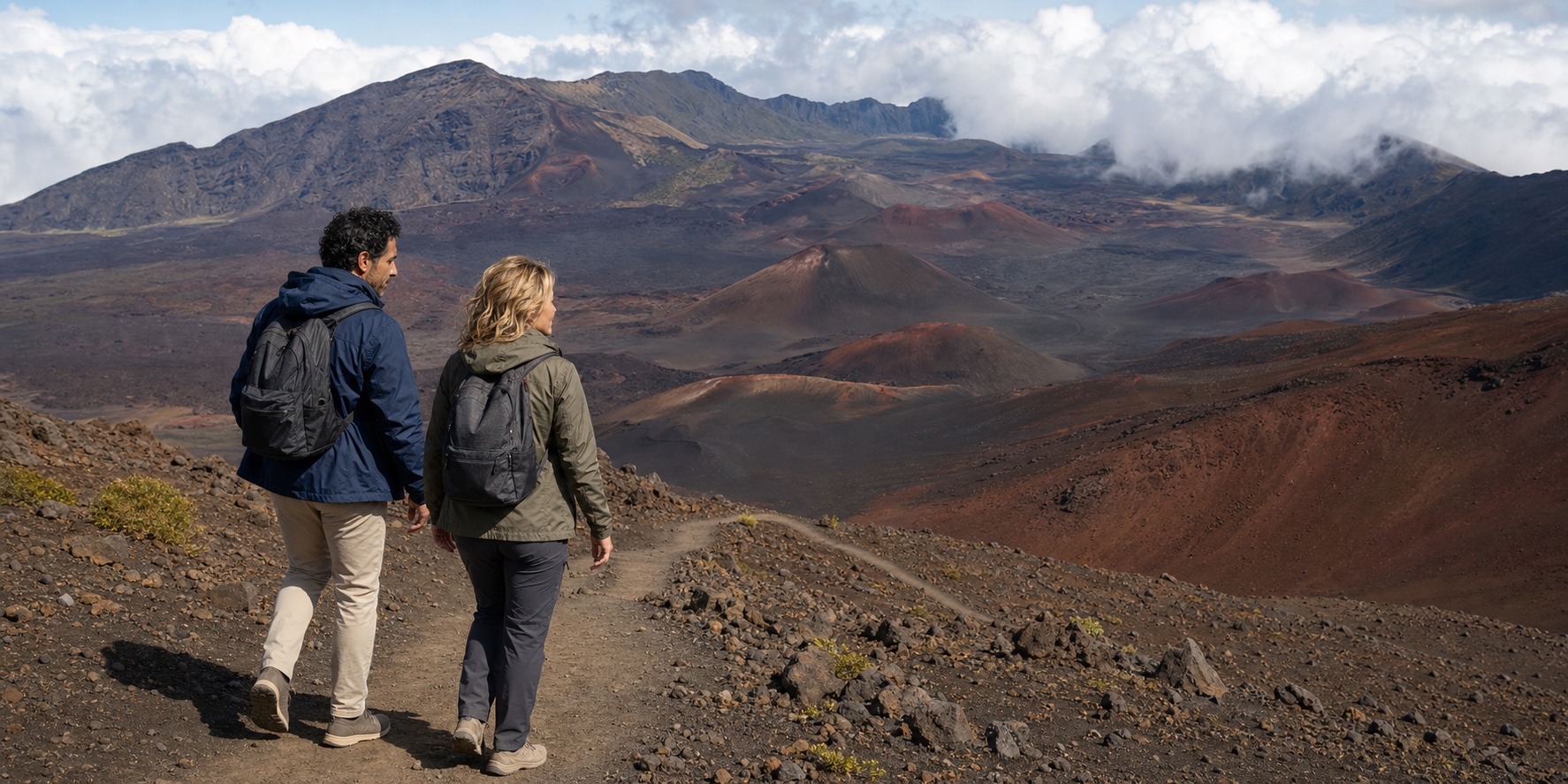
A four-mile guided outing on Maui turns out to be two high-elevation walks, a vehicle transition and a much larger story. Read the shield volcano, the Native Hawaiian cultural landscape, the rare life and the decisions hidden behind the mileage.
01 · Haleakalā summit field guide
The first surprise is useful — until it erases the place
Haleakalā can overturn the visual vocabulary of a Maui trip in the time it takes a vehicle to climb from the developed lowlands toward the summit. Warm air gives way to a cooler, thinner atmosphere. Cloud may sit below the road, cross it or hide the view altogether. Above the trade-wind cloud, dark cinder, rust-colored cones and great walls of eroded rock seem to belong to a different island. The ExcursionPass podcast behind this story reaches for the familiar comparisons: Mars, the Moon, an alien desert, a wasteland.
That surprise registers a real contrast, but “otherworldly” does little to explain it. The summit is neither empty nor geologically simple. It is a living high-elevation refuge, a landscape with enduring Native Hawaiian meaning, a wilderness managed under pressure and the visible part of an immense volcano whose slopes continue far beneath the Pacific. Even the word crater, useful on signs and tour pages, hides how the depression formed.
The recorded day also resists the tidy label “four-mile crater hike.” Episode 2965322 describes two two-mile walks, placing the lower, roughly 8,000-foot environment before the summit. The operator’s route description places the summit walk first, followed by a vehicle descent to the lower trail. A more detailed route account identifies Keoneheʻeheʻe, also called Sliding Sands, and Halemauʻu as the two out-and-back settings. The consistent structure is two separate walks and a vehicle transition; their order belongs to the day’s itinerary.
That sequence matters more than the round number. It means two descents, two return climbs, two trailheads, a change in elevation and vegetation, and repeated exposure to the physical effects of altitude. It also means the guide or operator can alter the plan for weather, trail or group conditions. A traveler choosing this day needs the real structure, not an old price, a review anecdote or an assurance that a lively guide turns thin air into an easy walk.
02 · Haleakalā summit field guide
Begin below sea level — conceptually
The summit elevation is 10,023 feet, but that number measures only the portion above the present ocean. The U.S. Geological Survey’s Haleakalā profile estimates that roughly 97 percent of the volcano’s total volume is below sea level. From a beach or airplane, a visitor sees the upper surface of a far larger construction rising from the ocean floor.
Haleakalā is the East Maui volcano. West Maui is the older volcanic mass at the other end of the island. In the deeper past, these and neighboring volcanoes formed the larger Maui Nui complex as lava production, erosion, subsidence and sea-level change repeatedly altered which land was connected. “Maui” is therefore a convenient present-day outline laid across a longer volcanic and oceanographic history.
The broad shape comes from shield building. Hawaiʻi’s volcanoes form as the Pacific Plate moves over a long-lived source of magma. Repeated, relatively fluid basaltic eruptions spread far from their vents and build low-angle slopes, layer after layer. The result is not the steep cone in a child’s volcano drawing. It is a shield so broad that the road can climb for miles while the mountain itself is difficult to perceive as one object.
That scale corrects a claim often made in older tourism copy: that Haleakalā is simply a giant dormant crater occupying some fixed percentage of Maui. Area slogans change depending on what someone counts — the volcano, its exposed slopes, the national park, the summit district or the depression. None explains the place as well as the physical relationship: East Maui is a vast shield; the national park protects selected summit and Kīpahulu landscapes; the hike visits short sections of two trails within the summit district.

03 · Haleakalā summit field guide
Build a shield, then let water and gravity work
Shield construction is only the opening chapter. As magma supply changes, eruption rate, vent location and lava chemistry can change too. Scientists describe East Maui as being in a post-shield stage. Rift zones — elongated regions where eruptions tend to occur — extend along the volcano, and later vents have produced cones and flows distinct from the broad shield-building form beneath them.
The lava itself is not one uniform black material. Hawaiian terms such as pāhoehoe and ʻaʻā identify contrasting surface textures created as basalt moves and cools. Pāhoehoe can preserve smoother, folded or ropy surfaces; ʻaʻā breaks into rough, clinkery fragments around a denser interior. Weathering, age, mineral alteration, plant colonization and light then complicate the tourist palette of red, black and gray. A trail surface that looks like sand may be loose cinder rather than beach sand, and its behavior under a boot is one reason an apparently short return can feel slow.
Water and gravity are equally important authors. Valleys cut into the volcano from the northeast and southeast. Over long periods, erosion enlarged the Koʻolau and Kaupō valleys until they opened into the summit region. Their meeting helped create the great depression visitors look across today. Later eruptions put new cones and lava flows inside it, partly filling and subdividing the eroded space.
This sequence explains why “crater” misleads when treated as a complete definition. The depression is not an impact scar and not simply the single collapsed mouth of the volcano. It is a composite landform: a shield altered by enormous erosion and then occupied by later volcanism. Individual cinder cones inside it are genuine volcanic vents, but they did not excavate the entire amphitheater around them.

04 · Haleakalā summit field guide
Not extinct, not a promise of imminent drama
Calling Haleakalā extinct would be wrong. Calling it uniformly dormant can also create more certainty than the evidence supports. USGS lists the volcano at a moderate threat level, dates the most recent eruption to a window between about 1480 and 1600 CE, and reports at least ten eruptions during the past thousand years. It expects future eruption to be possible, while monitoring and hazard science — not visitor intuition — determine what present unrest would mean.
Those facts do not turn a daytime hike into a volcano chase. A threat assessment combines the likelihood and style of future activity with what people and infrastructure could be exposed. It is not a daily forecast, and a colorful cone is not evidence of heat beneath a visitor’s feet. The active scientific position sits between tourism superlatives: Haleakalā is not an inert museum object, but there is no basis for inventing imminent spectacle.
That distinction becomes clearer beside Pacaya’s living volcanic route. Pacaya asks visitors to follow an active monitoring and evacuation chain around a frequently erupting complex; Haleakalā asks them to understand a moderate long-term threat without manufacturing a same-day eruption story. The shared responsibility is evidence-led conduct: read the responsible authority, stay inside current access rules and never treat a guide, a quiet morning or a dramatic photograph as a substitute for hazard information.
The youngest lava fields are concentrated along the southwest and east rift zones rather than uniformly across the summit depression. The existing landscape records eruptions of different ages over older rock, then centuries of wind, rain, temperature change and biological colonization. A trained guide may help distinguish a cone, a flow margin or a texture. A guide’s explanation is most valuable when it makes uncertainty and scale visible, not when it announces a secret geological fact unavailable to everyone else.
The same discipline applies to size. The depression is large enough to distort distance, and clear air can make a far wall seem close. Cloud can remove that scale in minutes. No fixed measurement conveys every rim-to-rim direction, and a marketed walk does not approach the basin floor. The NPS geology guide describes a summit depression about 3,000 feet deep and roughly 2.5 miles wide in one representative dimension. Treat those as orientation, not as a claim that every view is a symmetrical bowl.

05 · Haleakalā summit field guide
A cultural landscape, not the absence of people
The language of emptiness fails most seriously when it erases Native Hawaiian relationships to Haleakalā. The National Park Service’s summit interpretation describes the summit as a wahi pana, a storied and celebrated place, and as part of the wao akua, a realm associated with deities and powerful natural forces. These are not decorative translations for a viewpoint sign. They place the mountain within ways of understanding land, responsibility, genealogy and practice.
The mountain-to-sea connection offers a useful way to think about a wider Hawaiʻi journey. In Pearl Harbor and historic Honolulu, the sheltered harbor and Hawaiian capital have histories that extend before and beyond the military sites. Haleakalā likewise belongs to communities and relationships larger than the visitor attraction. Each island requires its own attention: knowing one famous place does not explain the rest of Hawaiʻi.
People traveled into and across the summit region for specific purposes. Park research identifies pilgrimage and ceremony, navigation, the work of kahuna and the production of stone tools among the activities tied to high places. Archaeological evidence includes paths, walls or enclosures known as pā, stone features called ahu and other sites whose meaning cannot be inferred merely by looking. The summit also participated in mauka–makai relationships: connections from mountain toward sea rather than a park boundary’s modern separation of ecosystems and communities.
Consider the adze makers. Dense, fine-grained stone from the summit quarry could become a koʻi, a tool used to work timber for houses and canoes. NPS dates quarry use to approximately 1200–1700 CE, possibly later, and explains that tools were often finished in coastal settlements such as Kīpahulu. The stone’s journey links a high volcanic source with skilled work and life near the sea. The park also credits Native Hawaiian scholar Thomas Kananiokeaupunimalamalama Maunupau’s knowledge and assistance in Kenneth P. Emory’s 1920s archaeological research. The surviving features did not explain themselves to an outside investigator; people helped make them intelligible.
The park’s archaeological timeline includes calibrated evidence of use between roughly 660 and 1030 CE, but an earliest surviving date is not a beginning myth. Archaeology records what material has endured and been studied; Native Hawaiian history also continues through language, family knowledge and practice. A visitor should not treat a numbered date as permission to place living culture safely in the past.
This changes conduct. Rocks are not loose souvenirs or raw material for a visitor’s personal cairn. Walls and alignments are not backdrops to climb. The park archaeology guidance asks visitors not to move, stack or take rock, and not to disturb structures or artifacts. Staying on trail protects more than a plant seedling: it reduces damage to places that an untrained eye may not even recognize as culturally significant.
“Sacred” can become another flattening tourism word if it is used only to create mood. The practical meaning is restraint: quiet where quiet is asked, no staged ceremony, no demand that Native Hawaiian knowledge be performed for an audience, and no assumption that public access transfers ownership of the story.
06 · Haleakalā summit field guide
Moʻolelo explains relationship, not a photo opportunity
The podcast repeats a compact account of Māui catching or slowing the sun. The story is widely associated with Haleakalā, but a responsible article cannot turn one brief version into universal Hawaiian mythology. The park’s discussion of nature and moʻolelo explains that moʻolelo do more than entertain. They carry knowledge, history and relationships that can continue to guide how a place is understood.
In the version presented by NPS, Māui’s mother Hina cannot dry her kapa, bark cloth, because the sun crosses the sky too quickly. Māui makes a rope of coconut fiber, ʻaha, climbs Haleakalā and catches the sun, obtaining a longer passage across the sky. The story begins with a household’s work and makes the mountain part of a relationship among daylight, skill and family. Retellings vary in participants, location, sequence and emphasis. A visitor need not hunt for a literal trap site or reenact the scene to understand that connection. The modern vehicle reservation system controls sunrise crowds; it does not explain the cultural meaning of sunrise.
Nor should a guide’s version become anonymous authority. A guide can identify where an account comes from, distinguish a living tradition from a personal interpretation and avoid presenting “the Hawaiian legend” as a single frozen object. A visitor can listen without demanding certainty or spectacle. Cultural knowledge gives the place meaning alongside geology; it is more than a flourish added to a view of red rock.
The English name “House of the Sun,” often given for Haleakalā, can likewise be an entry rather than an endpoint. A name participates in a language and a set of relationships. Preserving the kahakō in Haleakalā and the ʻokina in words such as moʻolelo and ʻāhinahina is a small act of accuracy, not proof of cultural competence. Correct typography matters; so does knowing when not to claim more.

07 · Haleakalā summit field guide
The road changed who could arrive — and what had to be managed
Modern access can make the summit feel inevitable: turn from Maui’s developed roads, climb Crater Road and stop near 10,000 feet. It was not inevitable. Before a road, Native Hawaiian trail networks crossed the mountain. Ranching later used summit land and paths; visitors reached the high country on foot or horseback. Haleakalā became part of Hawaiʻi National Park in 1916, and the present summit lands passed from ranch ownership to the federal government through a 1928 exchange.
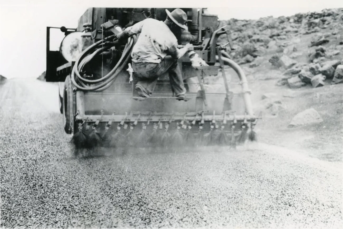
Tourism advocates wanted road access partly because volcanic sites on Hawaiʻi Island were easier to reach. The park section of the Haleakalā Highway was built between 1933 and 1935. NPS records 255 workers and an unusually narrow construction corridor intended to limit additional access roads. Crews built drains, gutters, a bridge and lava-rock masonry into a high, unstable environment. The surviving infrastructure is a design and maintenance story, not merely a sequence of frightening bends.
The project was contested. The park’s historical exhibit reports Native Hawaiian protest against building a road on sacred Haleakalā. Contemporary newspaper accounts filtered those objections through predictions of supernatural punishment, a framing that can trivialize a political and cultural position. Another complaint, from novelist Armine von Tempski, was that road access removed the adventure. These objections were not equivalent: one concerned relationship and desecration; the other concerned a tourism experience.
When the road opened in 1935, visitation rose sharply and the summit required more facilities and full-time management. That cause-and-effect continues. A road widens access, including access for people who cannot hike, while also concentrating vehicles, noise, wildlife risk, parking demand and pressure on cultural and natural resources. Sunrise reservations, speed limits, pullouts and closures are not annoyances attached to the “real” attraction. They are the current engineering and governance of access.
08 · Haleakalā summit field guide
Two trails, two debts to repay
The summit-first format begins with two miles in the high cinder landscape, changes trailheads by vehicle, and finishes with two miles in a lower plant community. To understand its effort, follow each walk separately. The rounded elevations distinguish environments; they do not identify the summit itself as a trailhead.
On Keoneheʻeheʻe, the NPS wilderness page places the trailhead near 9,740 feet, below the 10,023-foot summit. The path descends into the exposed depression. A short out-and-back gives changing angles on the cones and slopes without committing to the far floor. Halemauʻu begins at about 8,000 feet and approaches the rim through more vegetated terrain. It has a different surface, setting and elevation profile; completing the first walk does not tell you how the second will feel.
The park’s hiking guide places the first Keoneheʻeheʻe overlook about a quarter-mile from the trailhead; the crater floor is about 3.9 miles one way and nearly 2,500 feet lower. A one-mile outward walk therefore goes beyond the first overlook but nowhere near the floor. Its return climb depends on where it turns. One horizontal mile alone does not specify 1,000 feet of elevation gain, and a four-mile total divided between two trails cannot be read as a crater-floor return.
On Halemauʻu, NPS describes a 2.2-mile round trip to a first viewpoint with about 400 feet of elevation change. A roughly two-mile outing may turn before that viewpoint. Do not make the panorama a condition of success or continue independently to collect a view the group has decided to leave. The route beyond the rim begins a much larger wilderness commitment.
The vehicle transition is part of the guided format. It changes temperature, wind, cloud, vegetation and how the group’s legs feel after the first climb. It also gives the guide a decision point. Weather, trail state, group condition or park direction can alter a segment. The durable structure is two inverted walks with a vehicle reset between them; field judgment and park authority determine the route that day.

09 · Haleakalā summit field guide
Why four miles can feel unlike four miles at home
Both walks are inverted. The outward leg descends; the return collects the elevation debt. That geometry encourages a predictable mistake: a hiker feels strong while gravity helps, continues farther than planned and discovers the harder work only when the vehicle is uphill. NPS tells crater hikers to allow roughly twice as long to climb out as to descend. The rule is deliberately conservative and cannot replace a turnaround time.
Loose cinder increases the cost. A foot may slide slightly, the surface may give way, and repeated stabilization recruits muscles differently from a firm path. Wind changes balance. Strong sun and low humidity increase water loss without making the air feel hot. Cold can become noticeable during a stop after sweating. Cloud can remove visual landmarks and make a group’s separation more consequential. The trails are established but unpaved, and neither short format removes the exposure of the summit district.
The NPS caps day-hiking groups at twelve. A commercial departure may set a lower capacity, but that is a mutable service field rather than a park fact. Whatever the number, “small group” is not a safety system by itself. The guide needs to be able to see the group, notice changes, communicate a turnaround and keep people together at junctions. Each participant still has to disclose relevant limitations and speak when symptoms begin.
Facilities cluster at developed areas, not along these walks. Restrooms exist at several summit facilities and trailheads may have toilets or portable facilities, but there is no bathroom on the route. Water is available at designated visitor facilities, not as a natural source to rely on. The park has no food or fuel for sale. Mobile service is limited at trailheads and absent in much of the depression. A guide’s vehicle helps logistics; it does not make rescue immediate.
This is why the right fitness question is not “Can I walk four miles?” It is “Can I descend and reclimb loose, exposed trail twice after a rapid ascent to 8,000–10,000 feet, while managing weather and a fixed group schedule?” A person may answer yes and still turn around early. That is competent mountain judgment, not a failed vacation.
10 · Haleakalā summit field guide
There is no guaranteed lush-to-Mars sequence
The two trailheads span roughly 1,700 feet of elevation, enough to reveal different plant communities and weather, but not enough to support a guaranteed script. The lower Halemauʻu segment can cross subalpine shrubland with more visible native plants. Keoneheʻeheʻe begins in a colder, more sparsely vegetated high-elevation environment. On one day the contrast may be dramatic; on another cloud, drought, season or flowering cycles may blur it.
Trade winds often push moist air against East Maui. Rising air cools and forms cloud, while a temperature inversion can cap that cloud layer below the summit. Above it, conditions may be dry and brilliantly clear even when the lower road is wet. The inversion can shift or break. Leeward and windward exposures differ. A single weather icon for “Maui” therefore says almost nothing about the summit.
NPS advises visitors to expect daytime summit temperatures well below the coast, with wind chill that can drop below freezing. Its safety page gives broad typical ranges but also warns of storms with much stronger wind and colder conditions. Those are planning envelopes, not a promise that every hike is freezing. The useful rule is layers that can be adjusted: a moisture-managing base, insulating layer and wind/rain shell, plus sun protection. Cotton beachwear and a blanket left in the van do not solve moving between sun, wind and exertion.
Visibility is never owed. Cloud can create a powerful experience without revealing the depression, but the commercial value proposition understandably emphasizes views. A traveler for whom the panorama is essential should check the park’s live conditions and a summit-specific National Weather Service forecast close to departure, then accept that a forecast is not a guarantee. A guide can choose a safer or more informative route; no guide can produce clear air.
11 · Haleakalā summit field guide
ʻĀhinahina: long patience, one flowering
The Haleakalā silversword, ʻāhinahina, is a powerful correction to the word barren. A low rosette can look metallic against cinder because narrow leaves are covered in silvery hairs. Fleshy leaves, compact form and other adaptations help the plant persist through intense ultraviolet exposure, large temperature swings, wind and limited moisture. The exact function of every hair should not be improvised into a neat story about reflecting all radiation or harvesting every drop of cloud.
Its life history is more interesting than the podcast’s fixed fifty-year formula. The NPS silversword profile gives a documented span from about three years to more than ninety. The plant grows as a rosette for years, flowers once in a tall burst, disperses seed and dies. That strategy is called monocarpic: one reproductive event after a long investment. Age alone does not determine success. Weather, pollination, seed production, seedling establishment and survival all have to align.
Protection has changed the species’ prospects before. Visitors once pulled plants as souvenirs. Introduced goats and other ungulates browsed and disturbed habitat. Fencing, removal of invasive animals, weed control, monitoring and education allowed substantial recovery. That recovery is not a finished triumph. A long-term USGS research project reported a roughly 60 percent population decline from 1990-era levels, associated especially with reduced rainfall. That research result describes a measured period rather than a live count of plants. The result complicates the visual impression of toughness: an adult rosette can withstand a brutal afternoon while the population’s recruitment fails over decades.
Off-trail feet add a preventable pressure. Seedlings and roots are easy to miss against cinder. A visitor stepping closer for a photograph may damage the very evidence the photograph is meant to celebrate. Staying on the established path is therefore not bureaucratic tidiness. It protects a slow demographic process.

12 · Haleakalā summit field guide
Birds connect summit, sea and road
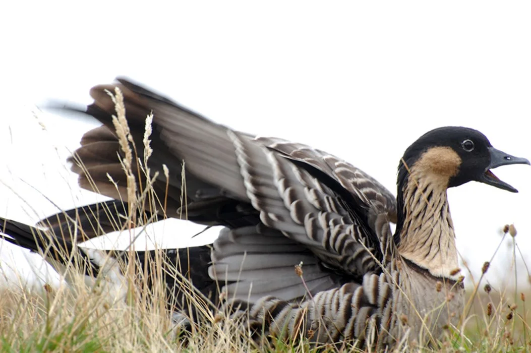
Native birds prevent the summit from being treated as a self-contained rock exhibit. The nēnē, Hawaiʻi’s endemic goose, uses grassland, shrubland, roadsides and high country. Its feet are better suited to walking volcanic terrain than the strongly webbed feet of many geese. The species was extirpated from Maui before reintroduction work began in the 1960s. Seeing one near a parking area is not an invitation to feed it or pull over in the traffic lane. It is a reason to obey the speed limit and let wildlife cross.
The ʻuaʻu, Hawaiian petrel, makes an even longer connection. It feeds at sea and returns to high-elevation burrows to breed, often traveling at night. The park’s summit bird guide associates nesting habitat with the walls of the summit wilderness, including areas around Halemauʻu and Hōlua. A daytime hiker is more likely to encounter the conservation landscape than the nocturnal bird: fencing, predator control, restrictions and the expectation of quiet.
Forest birds belong to another elevation band, including Hosmer Grove and wetter slopes. Climate change can move mosquito habitat upslope, increasing exposure to avian malaria in refuges that were once too cool for the vector. That is why a simple descent from “lifeless summit” into “lush forest” misses the ecological system. Temperature, rainfall, invasive species and disease connect the bands.
Invertebrates matter as well. Hawaiian insect lineages evolved in isolation, while introduced Argentine ants and yellowjackets can disrupt food webs and threaten native species. Food scraps, dirty gear and unauthorized movement of biological material have consequences beyond litter. Biosecurity can be as modest as cleaning boots before entering sensitive habitat, keeping packs closed and never transporting a plant, rock or animal.
13 · Haleakalā summit field guide
Conservation is work a visitor can either support or undo
The summit landscape looks severe enough to defend itself. It does not. Native species evolved without hoofed mammals, mongoose, many aggressive ants, landscape-scale roads or hundreds of thousands of annual vehicle arrivals. Some are resilient to wind and cold but vulnerable to trampling, browsing, predation or slow climate shifts. “Fragile” does not mean weak; it means the system has specific limits.
Much of what appears natural reflects decades of labor: fences checked and repaired across difficult terrain; invasive animals removed; rare plants counted; bird burrows monitored; weeds controlled; historic masonry maintained; trails defined; cultural sites documented; road shoulders managed for wildlife; and visitor numbers regulated at the most crowded hour. A four-mile tour crosses the results of that labor even when the guide never names it.
Trail discipline is the most immediate visitor contribution. The current Superintendent’s Compendium requires hikers to remain on established trails in designated areas and prohibits disturbing natural and cultural resources. Drones are prohibited. Day-hiking groups are limited. Fire, severe weather, infrastructure failure, resource protection or emergency response can close areas. A social-media image or old blog post does not override a barrier or ranger direction.
Sunrise controls illustrate the capacity problem. Vehicles entering the summit district between 3 and 7 a.m. need a separate sunrise reservation in addition to park entry. Daytime hikers arriving after that window do not need the sunrise reservation, though they still need valid park entry and must follow current access rules. The system manages a concentrated vehicle surge, not the sun itself. Commercial access has its own park authorization chain, but it does not change the visitor’s obligation to obey closures, stay on established trails and protect natural and cultural resources.
Conservation also requires accepting an unphotographed day. Do not approach a nesting bird, cross cinder to isolate a silversword against a clean background, stack stones to “improve” a composition or speak over a quiet cultural place for a video. The most valuable image may be the one not made.
14 · Haleakalā summit field guide
Thin air changes the decision, not a person’s worth
A vehicle can move from near sea level to roughly 10,000 feet in a few hours. The body cannot complete meaningful acclimatization on that schedule. At altitude, barometric pressure is lower, so every breath delivers less oxygen pressure. Detailed CDC clinical guidance notes that inspired oxygen pressure around 10,000 feet is only about 69 percent of the sea-level value; the agency’s public high-altitude traveler guidance explains the symptoms and conservative response. Most healthy visitors can make a daytime visit, but performance is reduced and individual response is not predictable from confidence or fitness.
Acute mountain sickness typically involves headache after a recent ascent plus symptoms such as nausea, dizziness, unusual fatigue or poor appetite. Dehydration, cold, sun, exhaustion, migraine and other conditions can overlap, which is why a traveler should not self-diagnose every discomfort from a checklist. The operational rules are simpler: report new symptoms, stop ascending, rest and descend if symptoms worsen. Confusion, loss of coordination or breathlessness at rest is an emergency. Severe altitude illness is treated by descent and urgent medical care, not by encouragement to finish the mileage.
Physical fitness does not prevent altitude illness. A fast athlete may be tempted to descend farther and create a larger return problem. Children are susceptible too and may describe symptoms poorly. People with heart or lung disease, sleep-related breathing disorders, pre-existing low oxygen or other relevant conditions should discuss the plan with a clinician familiar with altitude. Pregnancy, recent surgery, medication effects, back or joint problems and balance limitations require individualized advice; a commercial age minimum is not medical clearance.
Day trips are generally less physiologically stressful than sleeping high because the visitor returns to lower elevation, but the hiking takes place during the abrupt exposure. Pace slowly from the first steps, drink normally rather than forcing excessive water, eat enough to support the day, protect skin and eyes, and resist using alcohol or sedating medication as a solution. A guide can observe, adjust and call for help. The guide cannot know an undisclosed medical history or guarantee a symptom-free visit.

15 · Haleakalā summit field guide
Guided transport solves some problems and creates a group contract
Crater Road is winding, steep in places and exposed to rapid weather changes. The park advises drivers to use established pullouts, switch on headlights in cloud or rain, obey speed limits, watch for wildlife and use a low gear on descent. These are ordinary mountain-road controls, not evidence that the road is a terror ride. Guardrails, visibility and road edge vary; the safe response is attentive driving, not a story about inevitable brake failure.
Guided transport removes the burden of navigation and parking from the hiker. It lets a professional watch the forecast, sequence the trailheads and drive the descent after exertion. That can be valuable for visitors unfamiliar with mountain roads or reluctant to leave a rental vehicle at different points. It can also concentrate responsibility: the group meets on time, follows the guide’s turnaround and speaks honestly about symptoms rather than hiding them to protect the itinerary.
The van does not eliminate motion sensitivity. People who become carsick on switchbacks should plan before departure, choose an appropriate seat if available and discuss medication with a clinician or pharmacist because some remedies cause drowsiness. Nor does guided transport eliminate road closures, wildlife delays, parking congestion or cloud. The operator decides what it can safely deliver; the National Park Service controls the land.
Self-driving offers more flexibility at overlooks and allows a traveler to stop after the first walk. It also assigns one person the full mountain descent after a tiring day. That driver must stay sober, alert and willing to use low gear. A self-guided hiker must carry a map, share an itinerary, understand the inverted trails and avoid extending a short walk merely because the complete Keoneheʻeheʻe–Halemauʻu through-hike appears on an app.
Independent visitors should distinguish the two-mile commercial pieces from the classic approximately eleven-mile through-route connecting the trailheads across the wilderness. The long route descends thousands of feet, crosses the depression and requires a vehicle plan. It is not an unbooked version of the four-mile product and should not be improvised after arrival.
16 · Haleakalā summit field guide
The hike is not the only honest way to meet the summit
The park accessibility page identifies accessible facilities at the Headquarters Visitor Center, Haleakalā Visitor Center and Hosmer Grove picnic area, with accessible restrooms at several summit locations. The summit building is reached by a steep ramp and may require assistance. Park trails are unpaved and not suitable for wheelchair use. Those limitations should be named before purchase, not discovered at the trailhead.
Access to an overlook and access to a cinder trail are separate claims. A paved or ramped facility can support orientation without making the unpaved descent suitable; the return climb, loose surface, wind and altitude remain the decisive practical barriers.
A traveler who should not take the two cinder walks can still experience important parts of the district. Developed overlooks reveal volcanic structure when cloud permits. Visitor exhibits introduce Hawaiian culture and park history. Hosmer Grove offers a shorter nature setting at lower elevation; NPS identifies accessible picnic facilities there while making clear that park trails are unpaved. A ranger program may add interpretation without committing to a four-mile schedule. Staying near the vehicle allows a faster descent if altitude symptoms appear.
Children need more than an age field. Maturity, altitude response, footwear, cold tolerance and the ability to communicate discomfort matter more than a birthday. Adults must be prepared to turn a family around without converting the decision into blame. Toilets are not available on the trail, and food, warm layers and water need to remain accessible rather than packed under luggage in the van.
Travelers with knee pain may find the descent harder; those with cardiopulmonary conditions may find the return harder; people with balance or vision limitations may be challenged by loose cinder and changing contrast. Back problems can be aggravated by uneven footing and time in the vehicle. None of these observations is a diagnosis. They are prompts for an honest assessment and, where appropriate, a conversation with a clinician.
The best alternative is not consolation. A shorter overlook day may allow more time for geology, culture and weather than a group focused on covering mileage. The standard is not how far someone descends into the depression. It is whether the chosen format respects body, place and conditions.
17 · Haleakalā summit field guide
Choose the format by responsibility, not by prestige
Four common formats distribute responsibility differently.
- Guided two-walk day: best for travelers who value transport, naturalist interpretation and a pre-set conservative structure. It still requires enough mobility and reserve for two downhill-and-uphill walks, honest symptom reporting and acceptance that field conditions can change the route.
- Self-drive with short official walks: best for a party with a rested mountain-road driver, strong navigation and willingness to choose one short trail rather than reproduce a commercial schedule. Use the NPS map and current trail notices, not the distributor’s marketing mileage as a self-guided plan.
- Overlooks and visitor facilities: best when altitude, mobility, young children, time or weather argues against cinder hiking. It preserves the option to descend promptly and can still support serious learning.
- Sunrise visit: a different product and a different access problem. It requires a vehicle reservation during the controlled 3–7 a.m. window unless covered by a permitted commercial arrangement, plus cold-dark preparation. Sunrise and a four-mile daytime hike should not be casually stacked into one exhausting morning.
No format guarantees solitude, visibility or transformation. A guided group may reduce navigation burden but move at a shared pace. Self-driving provides flexibility but creates parking and driver fatigue decisions. Overlooks improve physical access but do not make every facility barrier-free. Sunrise supplies dramatic light when weather cooperates but concentrates traffic and can magnify sleep loss and cold.
The right choice can change on the morning. Check official alerts, the summit forecast and personal condition. A closure, barrier or ranger direction is part of public-land governance, never an invitation to improvise a route. Safety and conservation outrank a saved itinerary.
18 · Haleakalā summit field guide
Let park authority outrank a saved itinerary
Before leaving the lowlands, have the day’s essentials where you can reach them: water, food, warm layers, a wind and rain shell, sturdy footwear, sun protection and an offline map. A supplied day pack can be useful, but check what you will carry yourself and keep medication and essential personal items accessible. Decide how you will communicate a turnaround and how you will return to lower elevation if someone becomes unwell. These decisions matter more than reproducing a recorded sequence.
Park authority is separate from a commercial itinerary. Read alerts and conditions, fees and reservations, and hiking guidance close to departure. NPS requires a vehicle reservation for summit entry during the controlled 3–7 a.m. sunrise window; daytime hiking does not use that sunrise reservation. Save an offline map, use a summit-specific forecast and follow current signs and ranger direction. A four-mile label is never permission to cross a closure.
19 · Haleakalā summit field guide
Listen to the field notes — then let evidence revise them
Episode 2965322 follows the change from a beach-day expectation to cold high country. It notices how four miles can feel different at altitude, how cinder shifts underfoot and how two environments make one day. Its lower-to-higher sequence offers a way to imagine the contrast; the trail explanations above show what the rounded mileage leaves out.
The episode’s strongest moments are sensory: altitude, loose cinder, cloud, colour and scale. The geology and ecology are more complex than the familiar shorthand of a dormant crater, a fixed silversword lifespan or a guaranteed lush-to-Mars sequence. Hear the atmosphere, then let the landscape supply the explanation.
The correction does not drain the day of feeling. It gives feeling an object. Silence can be understood alongside the cultural importance of quiet and the nocturnal movement of ʻuaʻu. Color can be read through basalt, oxidation, age and plant colonization. The return climb can be anticipated through an actual route profile. A silversword can represent demographic patience rather than extraterrestrial decoration. A road bend can reveal a 1930s access project and a continuing public-land argument.
Listen with that richer map in mind. When the episode says wasteland, ask what work and life disappear from the word. When it says crater, picture shield construction, two eroded valleys and later vents. When it says secret, ask whether the real value is knowledge that should be sourced and shared carefully. When it says a guide will keep everyone safe, remember that safety is a contract among guide, traveler, park, weather and body.
20 · Haleakalā summit field guide
Leave with fewer superlatives and a clearer mountain
Haleakalā does not need to be the world’s largest dormant volcano, the closest place to Mars or a secret site to justify the climb. Those claims reduce a complicated landscape to a trophy. The stronger account is specific.
East Maui is a massive, mostly submerged shield volcano in a post-shield stage. Erosion opened the summit from Koʻolau and Kaupō; later eruptions placed cones and lava inside the depression. Future eruption remains possible, while present hiking is governed by weather, altitude and public-land rules rather than volcanic spectacle. The summit is a continuing Native Hawaiian cultural landscape, not an unpeopled stage. Its rare plants and birds survive through evolved strategies and sustained conservation, not because the environment is too hostile to touch them.
The researched two-walk format is two inverted out-and-back walks with a vehicle transition. One begins near 9,740 feet on Keoneheʻeheʻe; one begins near 8,000 feet on Halemauʻu. The chosen turnaround determines the return effort; advertised mileage alone does not describe cumulative elevation gain. Four miles can be a focused, complete experience. It should never be padded into the full wilderness traverse or minimized as an easy stroll.
The practical conclusion is equally specific: check the summit rather than the beach forecast; carry adjustable layers, water, food and sun protection; use sturdy footwear; disclose relevant health concerns; report symptoms early; stay on trail; keep rocks and structures where they are; give wildlife the road; accept cloud and closures; and choose an overlook if the hike is a poor fit.
That is not less romantic than an alien wasteland. It is a way of seeing more. The mountain becomes larger when the visitor stops asking it to look empty.