01 · Livingstone field guide
Begin with the river, not the country scorecard
Victoria Falls is often sold as a contest. Zimbabwe has the long panorama, Zambia has the close spray; one side is supposedly “best,” the other an optional extra. That comparison is easy to remember and too crude to plan with. The waterfall is a single transboundary system. The Zambezi approaches across a wide, island-dotted channel, meets the fractured edge of the Batoka basalt plateau, drops into the narrow First Gorge and then turns through a zigzag sequence of older gorges. Zambia and Zimbabwe divide access, administration and viewpoints. They do not divide the water.
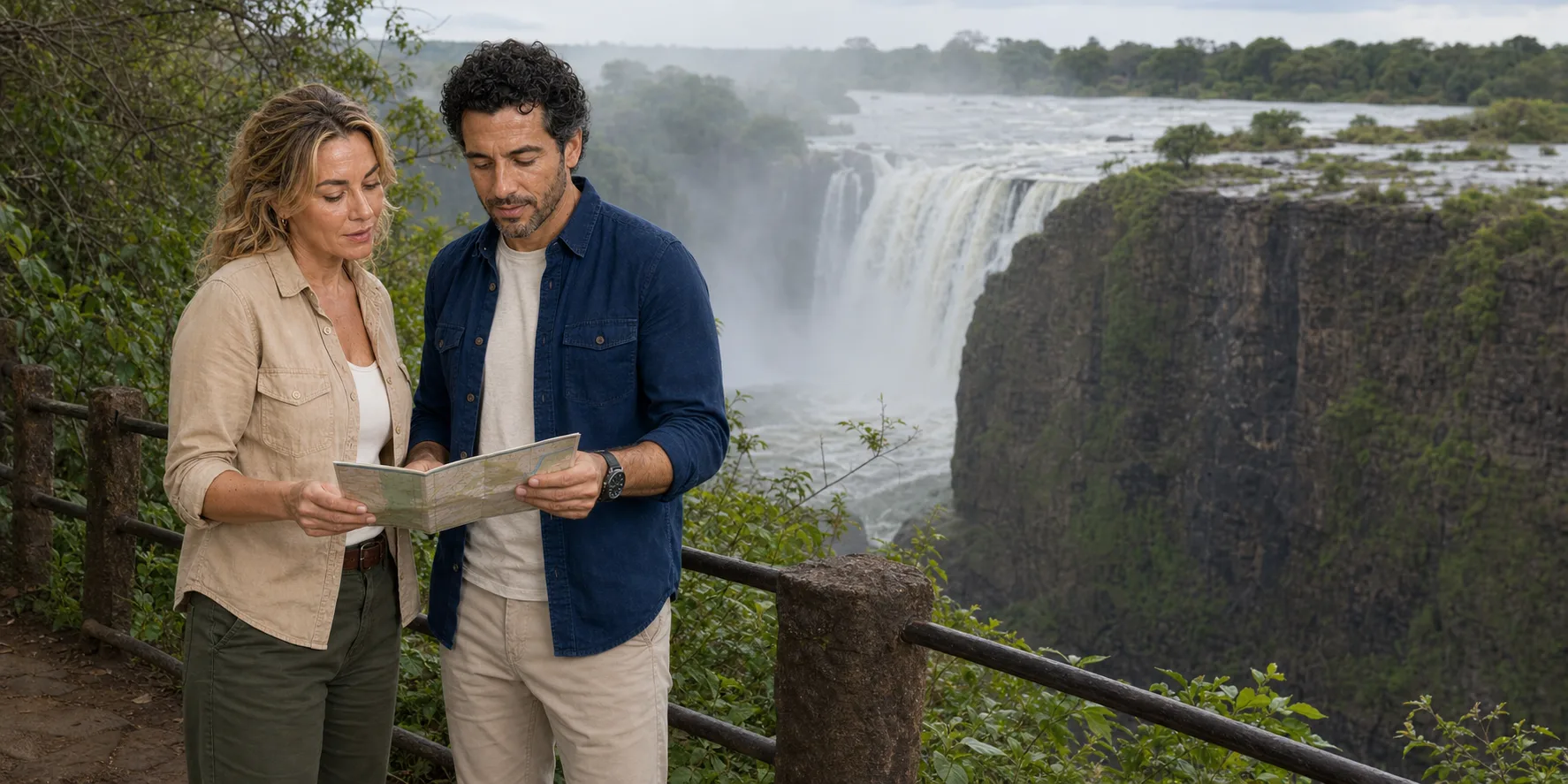
From Livingstone, the useful question is therefore not whether you have chosen the winning bank. It is what kind of reading the Zambia-side route makes possible. Here the path enters the spray zone opposite the Eastern Cataract, crosses the Knife-edge Bridge and offers changing relationships between falling water, cliff, mist and the river below. At high flow, water can become atmosphere: the view contracts, the sound expands and the path itself becomes part of the encounter. As flow recedes, the rock wall and the geometry of the gorge become more legible. Neither condition is a defective version of the other.
This distinction matters before you buy anything. A guided walk, a transfer from Livingstone, park admission, a border crossing, a visit to Livingstone Island and an activity at a seasonal rock pool are separate components. A product may include one and omit the next. The river may be suitable for one operation and not another. Immigration rules may make a Zimbabwe-side extension simple for one passport and complicated for another. Treating the day as a single bundle is how practical surprises accumulate.
The route can instead be built in layers: first the river and current flow; then the public path; then the geology and spray-fed ecology; then the human history and conservation responsibilities; finally transport, access and border choices. That order keeps the natural system in view while making each commercial or bureaucratic dependency visible.

02 · Livingstone field guide
The Zambezi does not follow a tourist calendar
“Wet season” and “dry season” are useful first approximations, but they can disguise the thing you actually want to know: how much water is reaching the falls during your visit, and what that flow does to visibility on a particular section of the cliff. Rain that falls far upstream takes time to travel through the upper Zambezi system. Local sunshine in Livingstone does not tell you the discharge at the falls, and a month that was spectacularly wet one year may look different the next.
The Zambezi River Authority publishes monitored flows from Victoria Falls–Nana’s Farm, one of its key hydrometric stations. Its long-term record is more informative than a recycled “best month” list because it shows the river as a measured, changing system. A recent number still needs interpretation: the gauge is upstream of the drop, a single daily or weekly reading is not a promise about visibility, and spray depends on wind and the distribution of water across the lip as well as total discharge. But the hydrograph tells you whether the river is rising, near a seasonal peak or in recession.
In broad terms, higher water brings a more continuous curtain and a much denser spray plume. On the Zambia-side path that can mean a forceful sensory encounter but fleeting or obscured views from the spray-facing points. Cameras emerge for seconds, then disappear into protection. Lower water exposes more of the basalt edge and the First Gorge. The Eastern Cataract can carry much less water, so the Zambia-side walk may reveal structure more clearly while offering less of the immense white curtain imagined from high-water photographs. The Zimbabwe-side viewpoints face a larger share of the main fall line and often preserve more falling water later in the cycle, but that is a different view, not a correction to Zambia.
The planning implication is simple. Decide what you value before interpreting the flow: sound and spray, an unobstructed cliff reading, photography, or a two-bank comparison. Then check a current official hydrograph close to travel. Do not convert a flow snapshot into a guarantee, and do not let an operator’s archive image stand in for the river you will meet.

03 · Livingstone field guide
What the Zambia-side walk actually does
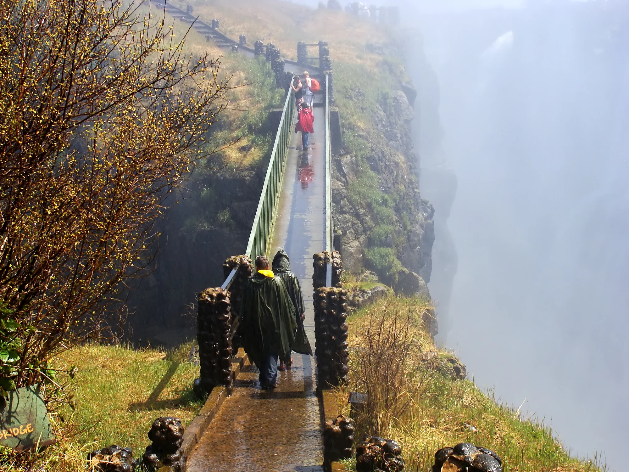
The main approach runs south from Livingstone toward the falls entrance. Inside Mosi-oa-Tunya National Park, the visitor route is a sequence rather than one balcony. It first establishes the broad river above the drop, then moves into vegetation maintained by spray, brings the Eastern Cataract into a close relationship and opens views along and into the First Gorge. The Zambia Tourism overview identifies the Knife-edge Bridge as the signature connection, with views toward the Eastern Cataract, Main Falls and the river’s turn toward the Batoka Gorge when spray permits.
That “when” is essential. At strong flow, the bridge can feel less like an observation platform and more like a crossing through rain. The official Zambia Tourism Agency description warns visitors to expect a soaking when the falls are at capacity. The bridge has railings, but it is narrow, exposed to spray and only one component in an uneven, wet outdoor route. A clear photograph taken in lower water does not demonstrate its conditions in higher water; a high-water photograph does not prove the view will always be opaque.
Other branches change the vertical relationship. The upper-river points look across water that still seems broad and calm before the brink. A descent toward the Boiling Pot moves down into the gorge environment, where the Zambezi turns below the falls and the international bridge occupies the sky above. That descent involves substantial vertical effort and should not be casually added for every visitor. The return climb, heat away from the spray, wet surfaces and time all belong in the decision.
The bridge that carries road, rail and pedestrians between Zambia and Zimbabwe is visible from parts of the route, but it is not merely another park footbridge. It sits between border posts and serves international transport. Walking toward or onto it can engage immigration procedures even if your intention is only to look. Keep the Knife-edge Bridge, the Victoria Falls Bridge and the activities operated near the river’s edge conceptually separate; the shared word “bridge” hides very different access systems.
A good guide adds value here not by promising a fixed list of viewpoints, but by reading the conditions: which angle has opened in the wind, where a surface is slick, what the exposed basalt shows at the current flow, which branch matches the group’s mobility and how the visible gorge relates to the river’s longer geological history. The public route remains understandable without a guide, but interpretation can turn spray and rock from scenery into a connected process.

04 · Livingstone field guide
Basalt, fractures and a waterfall that moves
The bedrock around the falls is a succession of Batoka basalt lava flows from the Jurassic period, roughly 180 million years ago. These flows cooled into thick sheets, with fractures and weaker boundaries that later gave water different lines of attack. The International Union of Geological Sciences account explains the landscape through river capture, structural control and upstream erosion. Water falling into a giant crack is the visible result; the history of how the river found and enlarged that route is the explanation.
The broad upper Zambezi flows over a relatively low-gradient plateau. At the current fall line, it plunges into the narrow First Gorge, exits through a constricted slot and turns sharply into the Second Gorge. Downstream, the channel follows a zigzag series of older gorges. These bends are not ornamental. They record earlier positions and directions in an evolving system, where erosion worked along structural weaknesses and the waterfall migrated upstream.
This is why a view into exposed rock at lower flow has real value. Dark, near-vertical cliff faces reveal the massive basalt. Vegetated ledges can mark more erodible zones or breaks between flows. The sharp change from a wide river to a confined gorge shows active landscape formation at a scale that is difficult to grasp from a single frontal photograph. The International Union of Geological Sciences recognises Mosi-oa-Tunya/Victoria Falls for geomorphology, tectonic control and active geological processes, not simply for height.
Nor did one sudden event create the entire modern visitor scene. The basalt is ancient; the river system and gorge sequence are much younger; the present fall line is one moment in a continuing erosional history. A rock age is not a waterfall age. “The crack” is not an empty split that appeared ready-made. The landscape is a conversation between lava-flow architecture, structural weakness, river capture and persistent erosion.

05 · Livingstone field guide
A forest made by spray
The mist is not only an obstacle to photography. It creates habitat. Across the gorge from the falling water, persistent spray maintains a humid microclimate that differs sharply from the drier woodland beyond it. The UNESCO statement of Outstanding Universal Value describes the riverine “rainforest” in the splash zone as a fragile, discontinuous forest dependent on abundant water and high humidity. That dependence makes the green rim part of the waterfall system rather than decorative framing.
At high flow, droplets settle on leaves, rock, path and visitor. Light changes rapidly as clouds of spray move across the sun. Rainbows are possible when the angles align, but they are an optical event, not a scheduled attraction. At lower flow, the spray footprint contracts. More cliff becomes visible and some vegetation receives less constant wetting. The path therefore offers an ecological transect: broad upper river, saturated splash zone, basalt wall, confined gorge and drier woodland beyond.
UNESCO’s natural listing also recognises the gorges as habitat for significant bird species. That does not turn a short falls walk into a reliable birdwatching checklist. Breeding sites can be inaccessible, disturbance matters and sightings depend on season, time, weather and expertise. The responsible expectation is to read habitat without demanding wildlife performance.
The same principle applies to animals elsewhere in Mosi-oa-Tunya National Park. The falls precinct and the park’s wildlife-viewing areas are related under one protected-area name but are not one continuous casual walk. A game drive or a guided wildlife activity has different safety, access and conservation rules. Do not wander beyond the signed visitor network because a map shows green space nearby.
The spray forest also changes how one should move. Wet vegetation narrows sightlines; surfaces can remain damp even when Livingstone is sunny; noise makes conversation harder; waterproof layers can reduce hearing and peripheral awareness. Slow down, stay within barriers, keep children close and let the place set the pace. Those are not emergency warnings. They are the ordinary conduct of entering a microclimate created by falling water.
06 · Livingstone field guide
Mosi-oa-Tunya is not a subtitle
“Victoria Falls” and “Mosi-oa-Tunya” are often printed together as though one were the official name and the other a colourful translation. The World Heritage property is formally listed as Mosi-oa-Tunya / Victoria Falls, a paired name that signals both the site’s African knowledge and the colonial history through which it entered European maps.
The widely used explanation, “the smoke that thunders,” captures the link between visible spray and sound. But a visitor should resist turning one phrase into a complete account of local identity. Communities in the wider Zambezi region have different languages, histories and relationships to the river. The falls were known, named, navigated around and interpreted long before David Livingstone saw them in 1855. Zambia Tourism’s historical overview explicitly corrects the old “discovery” formula: Livingstone was not the first person to see a place already embedded in local geography.
His arrival still belongs in the chronology. Guided by people with regional knowledge, Livingstone reached the falls during his Zambezi travels and applied Queen Victoria’s name. Later colonial infrastructure, mapping, rail travel and tourism amplified that name internationally. The city of Livingstone, the bridge and the museum all carry parts of this history. The responsible account neither erases Livingstone nor allows his biography to begin the waterfall’s human story.
Livingstone’s own 1857 account, in chapter 26 of Missionary Travels, gives that dependence on African knowledge a concrete form. The Makololo leader Sekeletu had intended to accompany him. When only one of the two requested canoes arrived, Sekeletu gave up his place. Near the falls Livingstone changed to a lighter canoe handled by men who knew the rapids, eddies and passages between rocks. They brought him to an island at the brink during low water. The familiar European name rests on a journey made possible by other people’s authority, equipment and skill.
This is a memoir written from one traveller’s position, with colonial assumptions of its own. It cannot speak for every community or provide instructions for approaching the river today. Yet the episode corrects the solitary-explorer image more effectively than a general disclaimer. The men navigating the canoe understood water that their passenger struggled to interpret. Livingstone also recorded names already in use before he renamed the falls. His written account belongs in the archive beside local knowledge; it does not replace that knowledge.
That is one reason to treat the Livingstone Museum as more than a room of explorer memorabilia. The institution describes collections in Zambian archaeology, ethnography, history and natural history alongside Livingstone letters and objects. Its own formation during the colonial period also deserves examination: collecting and classifying culture is never neutral. A visit can place the explorer within a much longer record and can show how Zambian institutions now curate, interpret and challenge inherited narratives.
On the falls path, language offers a practical discipline. Use Mosi-oa-Tunya as a place name, not only as an exotic quotation. If a guide explains a tradition or term, attribute it to the speaker and context instead of generalising it to every local community. Do not repeat an anecdote merely because it is vivid. The river’s documented geology and the region’s cultural meanings can coexist without being forced into the same kind of truth claim.

07 · Livingstone field guide
The bridge is engineering and border at once
The Victoria Falls Bridge was conceived within Cecil Rhodes’s imperial Cape-to-Cairo railway ambition and completed in 1905. Its steel arch was manufactured in England, shipped through Beira and assembled across the gorge. That supply chain is a reminder that infrastructure at the falls served colonial extraction and mobility as well as spectacle. For decades the bridge carried a principal rail route between southern Africa and what was then Northern Rhodesia.
Engineering made the location legible in a new way. The arch spans the Second Gorge downstream of the waterfall, where basalt walls provide the abutment setting and the narrow chasm reduces the required span. Road, rail and pedestrian movement share a structure suspended above the river. From the Zambia-side park, its form gives scale to the gorge; from the deck, the waterfall is partly visible but the experience is dominated by the international threshold.
The American Society of Civil Engineers’ landmark account identifies a steel-lattice arch with two hinges. Its members form a braced structure, carrying loads through the arch toward the gorge walls. Assembly presented a different problem: how to build across a deep void before a complete bridge existed. Materials crossed by cableway, while anchored cantilevered sections advanced from the two sides toward the centre. The finished curve conceals that temporary, outward-reaching construction sequence.
The deck also records changing transport needs. In 1929 it was altered from a two-track railway arrangement to accommodate a single railway line alongside road and pedestrian movement. The arch and the traffic surface therefore tell different parts of the history: an original structural solution below, an adapted circulation system above. Looking at the bridge from the falls path makes those layers easier to separate.
Zambia Tourism’s bridge history adds a striking episode from 1975. Negotiations over the future of Rhodesia took place in a railway carriage on the bridge. The setting brought representatives to a location at the boundary between political jurisdictions. A structure created for an imperial railway had become a meeting place in the struggle over the region’s political future. The bridge’s frontier role is embedded in its history, rather than merely imposed on it by today’s passport checks.
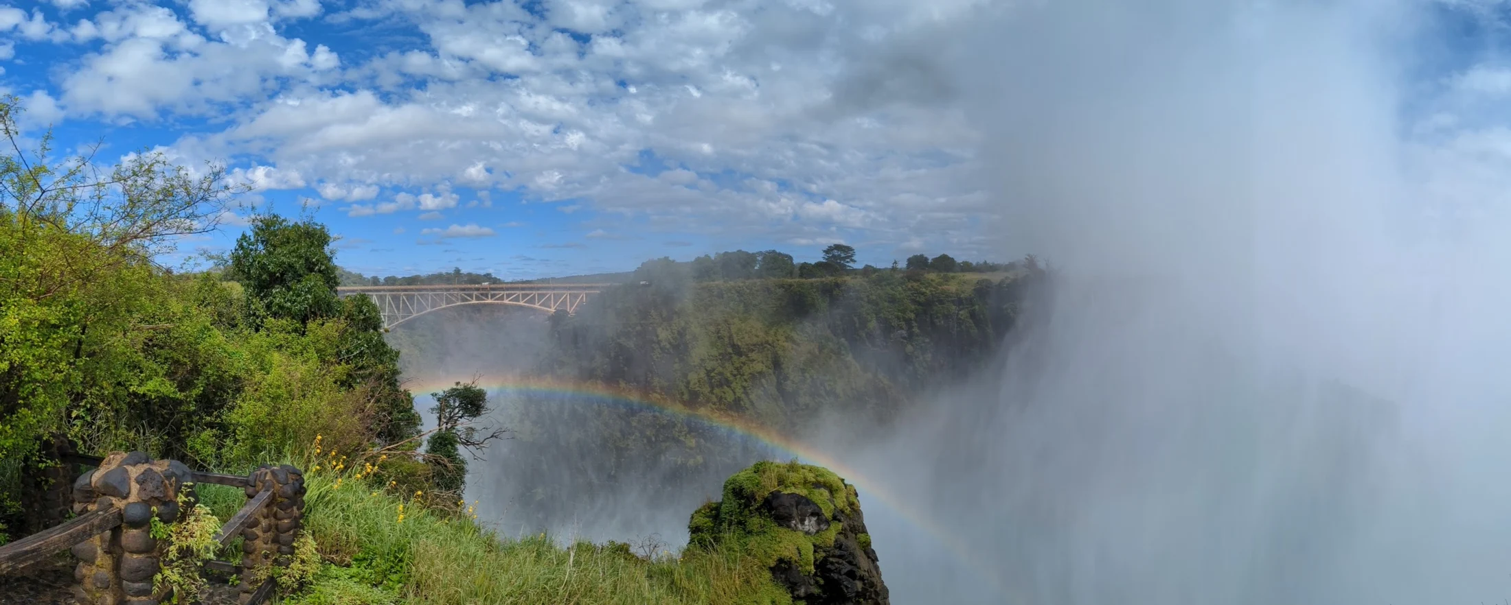

Today the bridge is neither a museum object nor an amusement platform alone. It remains working border infrastructure. Commercial bridge tours and adventure activities operate under their own terms. Pedestrians may be able to approach or cross, but border officials control movement and documentation. The apparent simplicity of “walk across for the view” should never outrun the immigration status of the traveller, the re-entry conditions of the country they are leaving or the operating rules of the day.
The bridge also helps clarify the two-bank problem. Zambia and Zimbabwe are not rival theme-park entrances attached to one attraction. They are sovereign states jointly responsible for a World Heritage landscape, each with protected-area agencies, immigration systems, tourism businesses and infrastructure. A traveller crossing for an additional perspective enters those systems. The water ignores the line; the visitor cannot.
08 · Livingstone field guide
Conservation is a transboundary negotiation
UNESCO inscribed the 6,860-hectare transboundary property in 1989 for natural criteria now numbered (vii) and (viii): exceptional beauty and important geological processes. The property includes land in Zambia’s Mosi-oa-Tunya National Park and Zimbabwe’s Victoria Falls and Zambezi national parks. Its integrity therefore depends on joint work across the river and on decisions beyond the immediate cliff edge.
The World Heritage Committee’s 2026 decision shows the practical tensions. It welcomes joint invasive-species control, monitoring, fire management and enforcement, while expressing concern about the cumulative effects of tourism and infrastructure in the property and its wider setting. The proposed Batoka Gorge hydroelectric scheme raises a further question: how would major downstream development affect the geological and visual values for which the landscape is protected? The Committee asks for assessment of alternatives before decisions that are difficult to reverse.
Joint management also involves enforceable limits. The decision treats the 2025–2030 Joint Integrated Management Plan as a draft needing revision before validation and implementation. It calls for clearer zoning, safeguards against development pressure, visitor management, monitoring responsibilities and sustainable financing. A plan’s title alone does not demonstrate that those protections are operating.
These responsibilities explain why a visitor encounters paths, barriers and controlled activities. A route concentrates foot traffic; a boundary protects a sensitive edge; a construction assessment considers effects beyond an individual site. Good management connects those small decisions to the river, habitat and views that make the whole landscape valuable.
The debates are not abstract. More rooms, roads, decks and activities can create jobs and extend visitor spending, but their cumulative footprint may alter views, habitat, noise, water or the sense of an intact geological system. A proposal can be commercially attractive and still require environmental assessment. Conversely, conservation that excludes local benefits or decision-making can reproduce older inequities. The relevant question is not “development or no development,” but who decides, what evidence is tested, which values are protected and how benefits and costs are distributed.
Visitors participate at a smaller scale. Stay on durable surfaces, do not feed wildlife, keep waste with you until a bin is available, avoid amplifying noise and treat souvenir purchases as transactions with makers or sellers rather than as proof of community benefit. If a guide explains a park rule, ask what it protects. That question connects personal conduct to the management system instead of reducing conservation to a slogan.

09 · Livingstone field guide
Livingstone before and after the falls
Livingstone is close enough to make the waterfall its economic and imaginative anchor, yet far enough that the falls should not consume the whole city. The road south creates a clear excursion pattern, but a thoughtful day can retain time for the city’s own institutions and ordinary life.
Founded in 1934, the Livingstone Museum provides a broad interpretive counterweight to a viewpoint-only visit. The institution describes five permanent galleries: archaeology, ethnography, natural history, history and David Livingstone. Read the explorer collection within that sequence. Letters and personal objects reveal an individual life; the other galleries place that life in the much longer histories of people, environments and material culture in Zambia.
The collections support research as well as display. The museum’s research account dates its archaeology section to 1957 and describes Stone Age and Iron Age holdings from sites around the country. A stone tool, pottery fragment or metal object answers questions through its material, manufacture and recorded context. An isolated attractive object tells much less. Looking for that context in labels is a useful way to read the galleries without needing specialist training.
Ethnographic collecting began with the museum in 1934 and continues alongside research. That chronology invites a question about every display: who selected the object, whose explanation accompanies it and how has interpretation changed? Communities represented in a museum remain living communities. A historic object cannot define all of their present practices. Natural-history collections offer another scale of evidence, preserving reference specimens that help researchers identify and compare Zambian wildlife beyond what a visitor happens to see on one day.
The National Museums Board describes the institution’s beginnings in a colonial-era collection of cultural objects. That origin matters when reading the galleries, but so does the present work of the Zambian museum. A visit can move from the history of collecting to the questions current researchers ask. Leave enough time for at least one gallery beyond the Livingstone material; otherwise the museum risks reinforcing the narrow chronology it can help expand.
The Railway Museum and bridge history can explain why Livingstone grew as a transport and administrative centre and how routes shifted over time. Markets and craft spaces can be valuable when visited as working commercial environments. Ask before photographing people or stalls, accept a refusal without negotiation and pay an agreed price without turning the exchange into theatre. A guide’s relationship to a particular shop should be transparent; a stop that mainly serves commission is not automatically cultural interpretation.
The city also makes the practical structure of the falls day visible. Transport to the park, luggage storage, cash access, connectivity, meals and rest all happen here. Confirm the arrangements you need with the business responsible for each. A guide can explain the city and park; a transfer company owns its pickup commitment; immigration officials control the border. Clear responsibility makes problems easier to resolve and prevents one delayed service from becoming a judgement about a whole place.
An overnight in Livingstone can create a better rhythm than trying to combine the falls, museum, wildlife, border crossing and river activities in one compressed day. The gain is not merely convenience. It lets the waterfall remain one powerful part of a lived region rather than a checklist item detached from its city.
10 · Livingstone field guide
Borders: decide the legal route before the scenic one
A two-bank visit can be illuminating. The Zimbabwe-side path generally faces more of the main curtain, while the Zambia-side route approaches the Eastern Cataract and gorge at close range. Together they explain the waterfall’s width and structure better than either side alone. But the border is not a ticket gate. Your right to leave, enter and re-enter depends on nationality, passport validity, visa category, arrival point and current policy.
The Zambia Department of Immigration’s KAZA UNIVISA page describes a shared Zambia-Zimbabwe document for eligible nationalities, issued at specified ports and subject to defined conditions. The department also maintains a broader visitor guidance page covering visa categories. Read both near travel. Do not assume that a friend’s passport, an old blog post or the presence of a border booth creates the same result for you.
The planning sequence should be legal first, scenic second:
- Identify every country you will enter and re-enter, including the country of your accommodation after the crossing.
- Check the official rule for your passport and intended port, not only the general name of a visa.
- Confirm whether your document allows the number of entries your route requires.
- Keep enough unscheduled time that a queue does not threaten a flight, activity or long-distance transfer.
- Carry the physical and digital documents requested by the authorities and follow border instructions.
Fees and eligible-country lists are mutable. Consult the official immigration page near travel for those answers, along with border hours and day-specific procedures. The durable planning principle is to identify the dependency early and resolve it with the authority that controls it.
A traveller who wants no immigration work can stay on the Zambia side and still have a complete falls day. A traveller who wants the transboundary comparison can plan it deliberately. Neither choice needs to be defended as the universally superior experience.
11 · Livingstone field guide
Safety is route-specific, not dramatic
Victoria Falls marketing gravitates toward superlatives and edges. The ordinary public walk requires a more precise safety language. Most visitors are not negotiating a wilderness expedition, but they are moving through spray, uneven outdoor surfaces, changing visibility, noise and occasional heat. The correct response is preparation and attention, not fear.
Treat every electronic item as exposed to driven moisture when the flow and wind are strong. “Weather resistant” has limits; a sealed pouch or dry bag gives a phone or camera a second boundary. Keep opening and closing to a minimum in spray. A rental poncho may protect clothing, but its availability, quality and price are commercial variables. Pack for the condition you intend to meet rather than relying on an entrance-side transaction.
Footwear should combine grip, secure fastening and comfort when wet. Do not depend on finding a particular rental shoe at the entrance. A heavy boot can become unpleasant when saturated; a loose flip-flop offers little stability. Choose for your own balance and the sections you plan to walk.
Keep hands available for railings. Do not climb barriers for a clear photograph, and do not step into an unsigned opening because another visitor did. In high spray, pause before moving from a bright area into mist so your eyes can adjust. In lower flow, exposed rock can make the gorge look more approachable without making off-route movement acceptable.
River-edge swimming activities are not extensions of the public path. Their operating windows depend on water level, and they require authorised operators, briefings and guides. Participation is an individual decision, but the boundary is firm: never infer that a pool is open because the month is usually associated with low water, and never attempt access outside the controlled operation.
The Boiling Pot descent is likewise a component choice. Ask about steps, surface, handrails, turnaround points, heat and the return climb. If a guide cannot answer, omit it. A complete visit does not require every branch.

12 · Livingstone field guide
Accessibility must be traced end to end
An entrance described as accessible does not prove that the full falls experience is accessible. The chain begins at accommodation and transport, continues through drop-off and ticketing, then divides among level approaches, wet paths, bridges, viewpoints, toilets, resting places and optional descents. It ends with the return vehicle. One broken link can change the day.
For the Zambia-side path, ask about your intended route and the exact mobility device or assistance you use. The Knife-edge Bridge is narrow and spray-exposed; the Boiling Pot is a descent. Those physical features do not determine the same result for every wheelchair, walking aid, sensory need or assisted-transfer plan. A description of the entrance is only the beginning of the discussion.
Ask the park or an operator component-level questions:
- Is there a step-free route from the vehicle drop-off to at least one falls viewpoint?
- What are the narrowest width, steepest gradient and surface changes on the intended path?
- Which sections involve stairs, and can each be bypassed without losing the whole visit?
- Are handrails continuous where spray reaches the path?
- Is there a dry, seated waiting point for someone who skips the bridge or descent?
- Are accessible toilets available inside the relevant entrance, and are they operating?
- Can the vehicle secure the exact mobility device without lifting or dismantling it unexpectedly?
- Who provides physical assistance, and has that assistance been agreed rather than assumed?
The Livingstone Museum states that its public areas are wheelchair accessible. That makes it worth discussing as a city stop with the museum directly, alongside transport, toilet facilities and the individual assistance you require. Its access statement does not describe the falls paths or a tour vehicle.
Photography, hearing and sensory access also matter. Heavy spray can make spectacles difficult to use, obscure lip-reading and amplify sound. A guide who walks ahead while speaking may become inaudible. Written route summaries, short interpretation stops away from the loudest points and agreement on hand signals can improve the visit without pretending to solve every barrier.
13 · Livingstone field guide
Guide, transfer, park and checkout are four different things
Tour descriptions often compress guide, transport, admission and route into one smooth sentence even when separate providers or payments sit behind them. Rebuild the bundle before paying:
- Guide: Is interpretation private or shared, and where does the guide meet you?
- Transfer: Is pickup included from your named accommodation, or must you reach the entrance independently?
- Park: Is admission included, prepaid or due separately, and does the booking cover only the falls precinct?
- Route: Are the Knife-edge Bridge and Boiling Pot optional, conditional or excluded?
- Border: Does the tour remain in Zambia? If it crosses, who explains the legal dependency without pretending to issue the visa?
- Access: What exact vehicle and walking components have been confirmed for your party?
- Checkout: Which live terms govern price, availability, cancellation and payment?
This is more useful than comparing star ratings. A polished review may describe a different operator, date, water level, pickup zone or product variant, so it cannot answer the component questions for your own booking.
Clear separation also protects good operators. If a guide delivers excellent interpretation but a seller misstates transfer, the problem belongs to fulfilment, not to the destination. If a vehicle fails to arrive, the responsibility belongs to the contracted chain, not to a cultural stereotype. Destination knowledge and booking terms can meet at clear facts without becoming the same promise.
14 · Livingstone field guide
Build a day that can breathe
A focused Zambia-side day needs fewer moving parts than the promotional menu suggests. Start with the falls when your energy and attention are fresh. Let flow and spray determine pace rather than treating every branch as compulsory. Allow a dry interval after the main route before handling unprotected electronics or entering an air-conditioned vehicle. Then choose one complementary layer: museum and city history, bridge engineering, or a separately managed wildlife experience.
Three structures work particularly well:
Falls and city
Use the morning for the Zambia-side walk, then return to Livingstone for the museum and an unhurried meal. This is the strongest first visit for travellers who want natural process and human history without a border crossing. It also creates indoor recovery time after a wet route.
Two banks, one system
Visit both public falls paths only after resolving immigration and re-entry. Treat the crossing as a real border movement and give each side enough time to reveal its geometry. The goal is not to count viewpoints, but to understand how a close Eastern Cataract encounter and a longer frontal panorama fit one fall line.
Falls and geology
Concentrate on the upper river, Eastern Cataract, First Gorge, bridge views and—only if suitable—the Boiling Pot branch. Add a separately arranged bridge interpretation visit or a geology-focused guide. Lower flow can make this version especially legible, though no season guarantees clear conditions.
Trying to add a safari drive, museum, two countries, a sunset cruise and a seasonal pool to the same day creates more transfers than understanding. A slower plan is not an admission that there is little to do. It respects the fact that water, history, border and city each need attention.

Water reshapes other places in different ways. Mont-Saint-Michel becomes clearer when tide is treated as infrastructure rather than a background effect; Hoover Dam and Lake Mead require measured water and governance rather than a reservoir snapshot; the Martha Brae is a working cultural landscape rather than a floating photo set. Mosi-oa-Tunya demands the same discipline at a far larger hydraulic scale.
15 · Livingstone field guide
A field checklist that leaves room for the falls
Several days before travel, look at the official Zambezi flow trend and decide whether your priority is spray, exposed geology, photography or a two-bank comparison. Check the current park information directly. If crossing a border, resolve entry and re-entry from official immigration sources for every passport in the party. Ask the operator only the questions it owns: meeting, transfer, route, vehicle and assistance. Let checkout own live price and cancellation terms.
Pack one reliable water boundary for electronics, secure footwear and a clothing plan that still works when wet. Carry only what you can manage with a free hand. Keep medication and travel documents protected separately from the camera. If you plan a city stop, do not assume wet gear will dry during a short vehicle transfer.
At the entrance, read the route before committing to branches. Ask which paths are open and where the strongest spray is reaching the walkway. Make a deliberate choice about the Knife-edge Bridge and the Boiling Pot descent. A person who turns around before either has not failed to visit the falls.
On the path, move slowly enough to notice the system: islands splitting the upper Zambezi; water accelerating at the lip; mist feeding forest; dark basalt beneath vegetation; the narrow outlet forcing the river to turn; the international bridge carrying modern movement across an older gorge. Those relationships are the story.
Afterward, resist the urge to rank the banks in one sentence. Ask instead what each position revealed and hid. Zambia may give you the body of the waterfall—spray, sound, cliff and crossing—while Zimbabwe explains more of its breadth. High flow may conceal geology while making the air itself feel hydraulic. Low flow may reveal the gorge while unsettling expectations built from flood-season advertising. The river has not failed in either state.
16 · Livingstone field guide
Listen to the Victoria Falls field notes
The accompanying episode collects the questions travellers bring to Livingstone: which bank to choose, how water level changes the encounter, whether a guide matters, what spray does to a camera and how a border complicates a day.
Open the 22-minute Victoria Falls episode. Listen for the route tensions, then use the reporting here for geology, cultural chronology, conservation, safety, access and the legal border sequence.
The most durable lesson is the one the river keeps giving: position changes perception. Stand close and spray can erase scale. Step back and panorama can erase force. Cross the border and the same waterfall enters another administrative system. Read all three—water, rock and human structure—and the Zambia-side journey becomes complete on its own terms.
Sources and practical references
- Zambezi River Authority flow monitoring
- UNESCO Mosi-oa-Tunya / Victoria Falls property and 2026 conservation decision
- Zambia Immigration KAZA UNIVISA guidance and visitor guidance
- Livingstone Museum
Check flow, access and immigration with the responsible institution near travel.