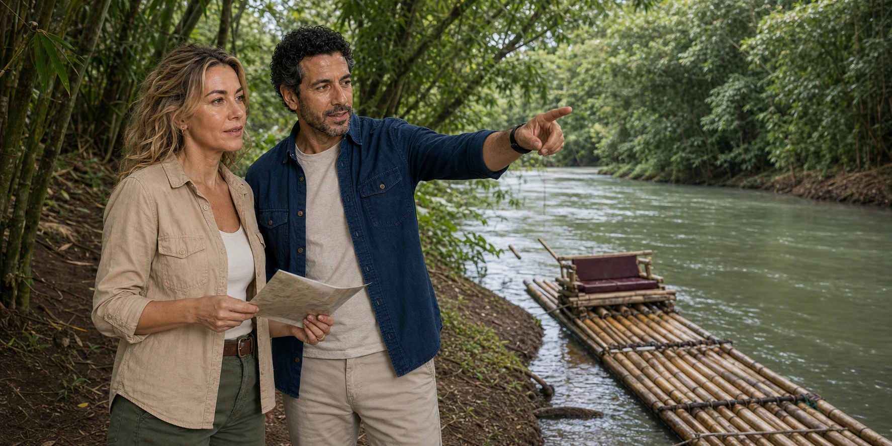
A bamboo raft is an unusually quiet-looking piece of transport. It is low, open and apparently simple: a long platform, a raised seat and a pole in the hands of the person doing the work. That simplicity can mislead. At Martha Brae, the river under the raft belongs to a limestone watershed; the route points towards an eighteenth-century port made wealthy by sugar and slavery; the bamboo itself is an introduced plant; and the modern passenger trip depends on licensing, dispatch, maintenance, road access and a captain’s accumulated knowledge of moving water.
The journey offers a way into a worked cultural landscape: one where a passenger’s quiet hour rests on someone else’s skill, and where water has carried trade, supplied a town and sustained communities. Understanding those connections also helps you decide whether a raft trip fits your day.

01 · Martha Brae river field guide
First, place the river correctly
Martha Brae is in Trelawny Parish on Jamaica’s north coast, close to Falmouth. The town faces the Caribbean Sea; south of the coastal plain, the land rises into the limestone hills of the island’s interior. The river gathers water from a basin that reaches towards the Cockpit Country landscape before running north through settlement and farmland. Montego Bay lies west along the coast, while Ocho Rios is farther east. These are gateways to the river, with different road journeys, rather than interchangeable names for its location.
The organised attraction takes passengers from Rafter’s Village inland to Rafter’s Rest downstream. The operator describes an approximately three-mile passenger section, rafts about 30 feet long and a ride of roughly 75 minutes. Treat these as the attraction’s planning description: water level and dispatch affect the journey, while check-in, waiting and road transfers add time beyond the ride itself. A trip beginning at a cruise pier or hotel is consequently a different commitment from arriving independently at the river.
Location changes the transport calculation. Travellers may originate at Montego Bay, Ocho Rios, a resort outside either town, a cruise pier, a villa or a private address. Obtain a written pickup point, vehicle type, road-time allowance and return plan for your own origin. A hotel transfer, a cruise excursion and direct admission can include different services even when each is sold as Martha Brae rafting.
Follow the route through four stages: arrival and check-in; the walk and transfer onto the raft; the downstream passage; and disembarkation and the return connection. The downstream landing is a separate place from the departure point. Captains and rafts have to return upstream too: reporting on the attraction shows a specialised vehicle carrying rafts back by road. That otherwise invisible return helps explain why a journey with the current still needs a coordinated transport system.
02 · Martha Brae river field guide
Limestone does not make water automatically pure

The Martha Brae sits in a karst landscape. Rain can move into joints, fractures and cavities in limestone, recharge groundwater, emerge through springs and feed surface channels. That relationship helps explain why a river can continue to carry substantial water beyond the moment of rainfall. It also makes the visible river only one part of a larger system.
The Water Resources Authority defines a basin through both surface water and the associated groundwater system. A boundary drawn around visible tributaries is therefore only part of the picture. In limestone country, subsurface movement may connect areas that a road map makes look separate. Groundwater moves according to differences in hydraulic head—the energy associated with elevation and pressure—rather than simply following the river’s visible bends. Springs bring part of that hidden circulation back into view.
Flow responds to rainfall, groundwater storage, abstraction and the condition of tributaries. Intense rain can raise water levels, move sediment and destabilise banks; a dry period can reduce flow. Upstream agriculture, sanitation, settlement and waste practices can affect water downstream even where the riverbank looks densely vegetated. Monitoring at different sites matters because a single attractive reach cannot represent an entire watershed.
Water colour is especially easy to romanticise. Suspended particles, dissolved material, depth, light, algae, recent rain and reflections from surrounding vegetation can all influence what a visitor sees. Limestone is not a certificate of microbiological safety. The Jamaican water-quality atlas records monitored chemistry across groundwater systems; it does not establish the suitability of a particular raft landing for swimming.
A limestone or mud application offered during a river outing is an optional activity, not a medically established benefit of the landscape. Natural recreational water can carry germs. Plan to remain on the raft unless the operator and current local health advice expressly permit swimming. Declining a hand treatment, swim stop or any other physical contact is a normal choice, and a captain’s hospitality should never be mistaken for medical advice.
The same discipline applies in a very different limestone landscape. Our Tulum and Cobá field guide follows rain through porous rock into a regional aquifer and asks who monitors the water, sanitation and visitor load. Martha Brae is a surface river in Jamaica, not a Yucatán cenote system, but the comparison sharpens one durable rule: clear-looking water is evidence of appearance, never proof of purity or responsible management.
03 · Martha Brae river field guide
A river that served a sugar port

Martha Brae village preceded Falmouth as Trelawny’s capital. The Jamaica National Heritage Trust records a 1772 project to clear the river for boats and barges. The growing trade needed a coastal harbour capable of handling larger vessels, and Falmouth became a major port. Sugar and rum moved through its wharves; the surrounding estates depended on enslaved African labour.
The wharves tied particular estates and merchants to the sea. JNHT’s port history describes installations associated with major landowners, including John Tharp. Cargo did not appear at the waterfront by itself: people planted and cut cane, processed it, maintained machinery, transported produce and loaded ships. The same economy required domestic service, building work and skilled repair. A handsome waterfront was one visible result of those unequal relationships.
Falmouth’s street grid and Georgian buildings make that economic order legible. Symmetrical facades and formal proportions sit alongside adaptations to tropical heat: verandahs, projecting eaves and ventilation through louvres. Look at how a building manages shade and air as well as at its decorative trim. This is a town shaped by Atlantic trade and local climate, with streets that still carry ordinary traffic and daily commerce.
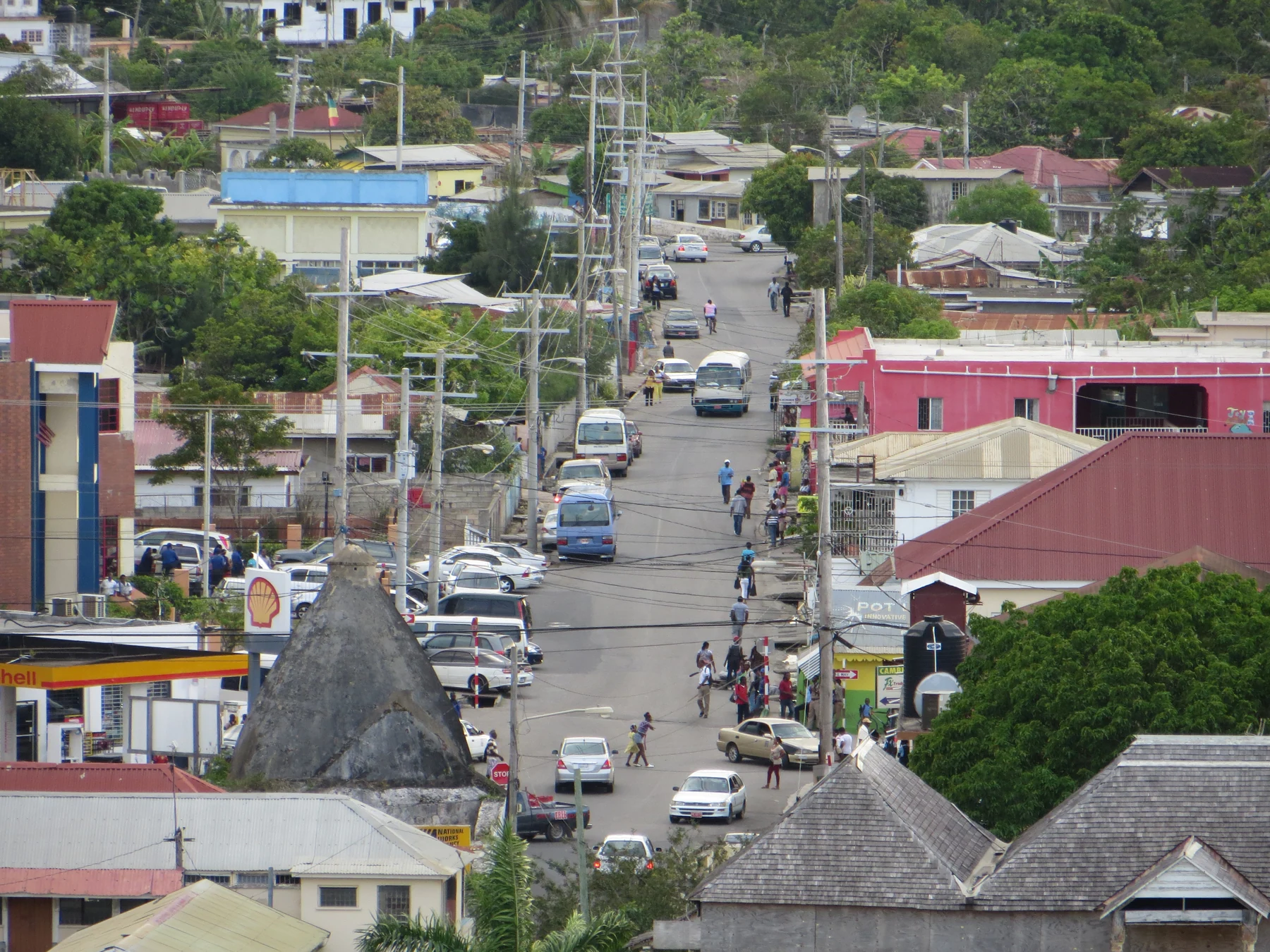

Changing ships helped change the port. As steam vessels grew larger and needed deeper water during the nineteenth century, Falmouth’s shallow harbour became a disadvantage; dredging was expensive. That shift provides a more useful explanation of the town’s changing fortunes than the idea that a historic port simply stopped in time. Surviving buildings belong to a place that has repeatedly had to adjust its relationship with the sea.
Emancipation also needs its full chronology. The British abolition legislation took effect in 1834, but many people were forced into an apprenticeship system that continued until 1838. Compensation went to slave owners, not to the people they had enslaved. The National Archives’ records expose that property-based logic. Legal freedom did not instantly distribute land or capital evenly.
New settlements offered a different way to claim a future. At nearby Granville, the heritage record describes Baptist missionary William Knibb’s purchase of ninety acres for a free village with approval from the Missionary Society in England. It was named for abolitionist Granville Sharp. Free villages belong in the river landscape’s history because housing, worship, work and access to land were part of making freedom practical. Granville’s history is a specific local example, rather than a claim that every settlement developed the same way.
Modern bamboo passenger rafts occupy this older transport landscape, but river navigation alone does not prove an unchanged craft tradition. An eighteenth-century cargo boat and a modern raft can share a waterway without sharing materials, dimensions or a steering system. The established attraction dates its recreational operation to 1970; River Raft Limited says it has operated it since 1985. Reception, dispatch, a defined passenger run and return transport belong to that modern visitor organisation.
Another Atlantic river city invites a careful comparison. In New Orleans’s French Quarter, port wealth, enslaved labour and later tourism are also compressed into an attractive historic scene. Falmouth has its own Jamaican history. In both places, looking beyond facades to cargo, households and waterfront work gives the architecture more meaning.
04 · Martha Brae river field guide
Water for the town

Falmouth also needed the river for something less conspicuous than export cargo: water for residents and ships. A low-lying coastal town faced a difficult engineering problem. The nearby river lay below the town’s level, and its lower reach could be brackish. Useful fresh water had to be taken farther inland and conveyed to the coast. Water Square preserves that history in a familiar town name.
Historian Aaron Graham’s study of the Falmouth Water Company, incorporated in 1799, follows experiments with a hydraulic ram supplied by Boulton and Watt. Installation began in 1802. A hydraulic ram uses moving water and pressure changes to lift part of a flow; it does not require a steam engine to do that work. Making the imported equipment function required adjustment to local conditions, pipework and skilled maintenance. Graham’s account brings African and European metalworking expertise into a history too easily told as the arrival of a British machine.
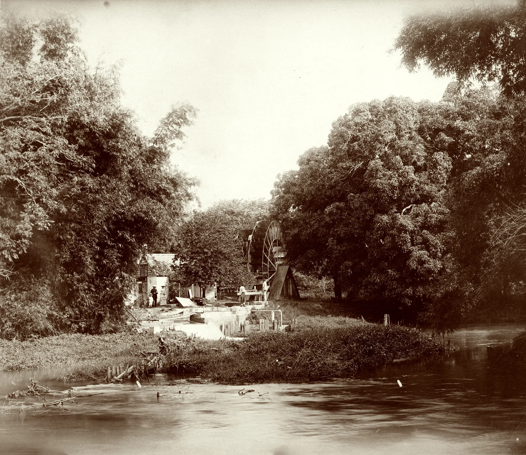
A later waterwheel system makes the mechanical problem easier to picture. The heritage trust describes paddles turned by flowing water and buckets around the wheel’s circumference. The buckets rose with the wheel, emptied into a trough, then descended to fill again. Pipes conveyed water towards a reservoir in the town. A wheel could transform the river’s movement into a raised supply; the pipes and storage completed the system. The waterwheel heritage account explains those components.
The historic photograph shows the wheel, its supporting structure and people beside it. It is evidence of a working river installation, not a picture of the present attraction. Seen together, the raft and the wheel reveal two different uses of the same resource: controlled movement on water, and energy drawn from water to serve a settlement. Keeping the labour behind each in view changes the river from scenery into infrastructure.
05 · Martha Brae river field guide
Martha and the river: history, language and oral tradition
In the operator’s version of a widely repeated legend, a Taíno woman named Martha is forced to reveal hidden gold to Spanish captors, then uses supernatural power to overwhelm them with water. Other retellings vary her name and describe her as a witch, princess or healer. The story gives its central woman an act of resistance: the people who try to extract wealth lose control of the landscape they seek to command. That is its narrative force, regardless of the differences between versions.
It should be heard as oral tradition, not transcribed as a verified sixteenth-century incident. Written evidence for individual Taíno lives in Jamaica is fragmentary and overwhelmingly filtered through European colonisers. Even the English name “Martha” signals layers of retelling. Attributing the story does not diminish it. It reveals how memory protects agency when the archive often records Indigenous people only through conquest.
Taíno communities lived in Jamaica before Spanish colonisation; disease, violence, forced labour and displacement devastated them. The historical scholarship provides a firmer context than treating a tour legend as a personal biography. Later Maroon and African-Jamaican histories shaped the interior too, with their own people, places and struggles.
The Cockpit Country’s steep limestone terrain mattered to Maroon resistance: routes, cover and knowledge of the uplands could frustrate forces unfamiliar with them. UNESCO’s tentative-list account connects the landscape to that history and to living communities. It is a proposal for heritage recognition, not evidence that the region is already inscribed as a World Heritage Site. A journey through the lower river does not constitute a visit to a Maroon community; any such visit needs its own welcome, interpretation and arrangements.
06 · Martha Brae river field guide
What the raft asks of its captain

Photographs of the established attraction show many bamboo culms laid lengthwise into a broad platform, a raised passenger seat towards the rear and a captain working nearer the bow. This arrangement leaves space for poling ahead while passengers sit behind. Bamboo contributes buoyancy through its material and enclosed internal spaces, but a floating culm is only a component: connections, seat stability and the condition of the whole platform determine whether a craft is serviceable.
An August 2026 interview with captains Claude Johnson and Richardo Geinues gives the construction a human scale. Johnson described a two-person job using fourteen long culms, even though captains called the bundle a “dozen”. The builders aligned equal lengths, held them together with ratcheting straps, threaded a stick through pierced ends and secured the assembly with wire. Smaller crosspieces supported the seat; the seat itself combined bamboo and wood. These are the methods described for that demonstration, rather than a universal recipe or a passenger load rating.
The reporting also shows why maintenance matters. Enclosed sections can lose buoyancy when they split or admit water, while damaged connections and an unstable seat create separate problems. Selection, repair and inspection keep a raft in service. A traveller can appreciate that workmanship without accepting an informal claim about the maximum weight the craft could carry.
The bamboo commonly naturalised around Jamaica includes Bambusa vulgaris, a widely introduced species rather than an ancient native emblem. Bamboo can grow quickly, but fast growth alone does not prove a closed, sustainable supply chain. Harvest site, regeneration, transport, treatment, replacement frequency and disposal all matter. Dense bamboo can also dominate a bank and interact with erosion in ways that depend on place and management.
Poling is similarly more than pushing backwards. The captain reads depth, current, obstructions, wind and the raft’s turning response. The pole can provide propulsion where it reaches the bed, hold the craft off a bank and alter its angle to the flow. Loading and passenger movement affect balance. High or turbid water can hide the features on which familiar judgement depends. That is why local experience matters—and why an operator must be willing to suspend a trip when conditions exceed the system’s safe limits.
07 · Martha Brae river field guide
A licensed attraction is also a labour system

Jamaica’s River Rafting Act and regulations provide for declared rafting waters, licensed rafts and licensed raftsmen, inspection and suspension or revocation. The regulations archived by FAO make the distinction concrete: the raft requires a fitness assessment, its licence identification must be displayed, and life-saving equipment must be provided for occupants. A captain’s authorisation and a craft’s fitness are related checks, rather than the same document. Ask the operator how both are maintained for the assigned journey; a pole and an available platform alone do not establish a regulated service.
River Raft Limited has long been identified as the attraction operator. Tourism Product Development Company material identifies its managing director in a governance role, confirming that the company is part of Jamaica’s formal tourism system. But corporate identity does not answer every labour question. How captains are assigned, paid, tipped, trained, insured, equipped and heard when they raise a safety concern are central to the quality of the trip.
Independent Jamaican reporting puts names and differing experiences into that structure. In a 2023 profile, Edgar Harrison described moving from masonry to rafting after a local captain offered him a departing colleague’s place. Training led to a career he said had lasted thirty-four years. Raised in Sherwood Content, he credited the income, carefully budgeted, with helping his three daughters attend university. Talking with visitors widened his understanding of the world. His account makes the encounter on the river a livelihood and exchange, with family consequences beyond the passenger’s day.
A 2012 community report shows another side. Residents argued that too little employment and craft income reached Martha Brae village. Management replied that the attraction employed people from across Trelawny and used local trades, including mechanics and builders. It also argued that additional shops could burden visitors when existing craft purchases were limited. The report described tourists leaving promptly after their ride, making it harder for nearby businesses to benefit. These were recorded positions at that time, not a verdict on today’s employment arrangements. They identify a durable question: how much of a visitor’s spending stays in the places the visitor passes through?
Tips, photographs and craft sales should operate through consent. Ask the operator what is included, whether tips are pooled or direct, which optional sales may occur and whether a passenger can decline without embarrassment. Carrying small cash may be convenient only if the operator currently confirms cash use; it is not an obligation. If an interaction crosses a boundary, report it first through the operator’s named channel and, where appropriate, Jamaica’s tourism or labour authorities. The Ministry of Labour and Social Security publishes complaint routes, but a traveller should not guess a worker’s employment status from a brief encounter.
The wider benefit question extends beyond the raft. Watershed communities live with flooding, road damage, water abstraction and land-use choices. A credible tourism model contributes to river maintenance, local employment and resilient access instead of extracting a photogenic hour from a place whose environmental costs remain public.
08 · Martha Brae river field guide
“Tropical” is not the same as untouched
The upper Martha Brae basin reaches towards the Cockpit Country, a limestone karst landscape where rounded hills and enclosed depressions create complex routes for water and pockets of habitat. The Forestry Department’s management material treats forest cover, land use and local livelihoods as connected concerns. The passenger corridor farther downstream includes native and introduced plants, farms, settlements, roads, managed attraction grounds and regrowing riverbanks. A raft trip offers a view of that mixed corridor; it cannot stand in for the ecology of the whole upland forest.
Birds may be present, but a rafting ticket cannot guarantee a particular woodpecker, heron or endemic species. Wildlife observation varies with season, time, noise, vegetation and chance. The ethical way to enjoy it is to ask a captain what has actually been seen recently, keep voices low and avoid feeding or touching animals.
The principal ecological pressures are also less cinematic than a wildlife list. Heavy rain can erode exposed soil and deliver sediment. Bank clearing can remove shade and root structure. Waste and wastewater can enter tributaries. Farms and settlements need water. Climate change is expected to increase the difficulty of managing heat, drought and intense rainfall in Caribbean islands. Flood debris at one landing can originate far upstream, making the attraction inseparable from the health of its wider catchment.
Conservation consequently begins with operational decisions—when not to launch, where to repair a bank, how to handle waste, where bamboo is harvested and how communities share information—rather than with the claim that a slow ride is inherently sustainable.
09 · Martha Brae river field guide
Safety begins with permission to say no
The operator’s published material says life jackets are supplied and captains are licensed, including CPR training. Those are useful baseline claims to reconfirm, not permission to stop thinking. Ask whether a correctly sized jacket must be worn throughout, whether children’s sizes are available, what happens in high water, how weather cancellation is decided and where emergency extraction is possible along the run.
Keep hands and feet on the raft unless the captain has clearly explained a safe action and you freely agree. Decline swimming, a limestone or mud application, photographs, drinks, sales and physical contact whenever you prefer. A calm setting does not erase the need for consent. If alcohol is available before departure, remember that balance, heat and moving water are a poor combination.
Natural water can contain infectious organisms even when it looks clear. Cover open cuts, wash hands before eating and seek current medical advice if you are immunocompromised or have a condition affected by heat, sun or prolonged unsupported sitting. After a storm or flood, assume risk has changed until authorities say otherwise.
Rain deserves a plan rather than a promise. Light rain may be operationally manageable, but lightning, rapidly rising water, strong flow, blocked access or unstable banks can require delay or cancellation. Obtain a written weather and refund policy before committing to transport costs.
10 · Martha Brae river field guide
Accessibility is an end-to-end question

A raft can look level and spacious in a photograph while remaining difficult to board. Avoid generic labels such as “wheelchair accessible” or “not suitable for disabled people.” The useful conversation is specific.
Start with the vehicle: step height, wheelchair or mobility-aid space, seat belts, child restraints, journey length and road surface. Then ask about the distance from drop-off to check-in, gradients, steps, handrails, toilets, changing space, shade and a dry waiting area. At the landing, establish whether the raft moves during transfer, what physical assistance staff can safely provide, whether a lift or stable transfer board exists and where a mobility aid will be stored and reunited with its owner.
On the raft, clarify seat width, back support, the ability to change position, exposure to sun and insects, life-jacket fit, communication with the captain and the consequences of needing to end early. Finally, confirm the exit landing and return vehicle. A workable outbound transfer is not accessibility if the downstream exit cannot be used.
The same chain helps families and older travellers. Do not infer that every baby or child is accepted. Ask for the current minimum age, adult-to-child ratio, jacket sizes, vehicle restraints and rules about lap-held children. Pregnant travellers and people with recent surgery, balance difficulty, back pain, severe allergies or heat sensitivity should describe their actual needs to the operator and their clinician rather than rely on a broad tour category.
11 · Martha Brae river field guide
Choosing the right format—or choosing not to raft
The right arrangement depends on where the day begins, how much connection risk it creates and what support the traveller needs.
Direct attraction booking can make the operator relationship clearest. The confirmation should specify arrival, cancellation, transport and a working contact for the day.
A transfer-inclusive package can reduce the number of connections. Verify the contracting operator, pickup zone, vehicle, waiting policy, attraction admission and refund responsibility. Avoid a reseller that cannot name the operator or explain who decides when weather or river conditions stop a trip.
A cruise or resort excursion may integrate ship or hotel logistics, but it can also compress the schedule and place several intermediaries between passenger and operator. Ask who makes the weather decision and whether return-to-ship protection is written into the contract.
A private driver offers control over departure and can combine the river with Falmouth, but agree waiting time, downstream pickup and cancellation terms. Do not assume the driver can enter every attraction zone or provide physical boarding support.
A combination day should be built around geography, not a list of famous names. Falmouth heritage and a north-coast stop can make sense if opening hours and road time leave margin. Crossing the island to add a distant attraction may turn a slow river experience into a transport race.
A non-rafting alternative is not a consolation prize. A guided walk through Falmouth’s port history, a heritage site with verified access, a local food experience or a landscape-focused day can engage Trelawny without entering moving water. It may be the better choice for mobility, weather, young children or a traveller who simply does not want sales or physical contact in a confined setting.
12 · Martha Brae river field guide
The practical confirmation chain
Before paying, ask the seller to answer these questions in writing for the intended date:
- Which regulated river attraction, landing and route does the booking cover?
- Who is the contracting operator, and who runs the raft and transport components?
- Where exactly are pickup and return, which vehicle is used, and what road-time margin is included?
- What are the current check-in time, raft policy, passenger limits and child rules?
- What is included, what may be sold optionally, and what are the tipping and photography arrangements?
- Who cancels for rain, high water, road damage or other safety concerns, and how is a refund issued?
- What toilets, changing, dry storage, drinking water, shade and food are currently available?
- How will the operator meet specific transfer, seating, communication, life-jacket or medical needs?
- What emergency number works on the day, and where can a journey end if a passenger becomes unwell?
Pack for exposure rather than for a brochure image: sun protection, insect protection, secure footwear appropriate to the confirmed boarding surface, water in a reusable container, essential medication and a small waterproof system for items the operator cannot store. Do not bring valuables on the assumption that a dry box exists. Ask before using a drone or photographing staff and communities. Keep enough schedule margin that refusing unsafe conditions remains a real option.
13 · Martha Brae river field guide
What the slow river can reveal
The slow journey can bring several scales into focus. A pole touching the bed belongs to the captain’s immediate task; the water beneath it belongs to a watershed; the downstream direction points towards a port; and the bamboo platform connects plant material to skilled work. Allow time to ask about what is actually beside the raft and to listen when the captain explains the craft. The value of the river lies in those connections as much as in the pause it offers from a crowded travel day.
Choose an arrangement that leaves time for the river, a comfortable transfer and a safe return. Good planning protects the freedom to decline an optional activity, while an informed conversation leaves room for the captain’s knowledge. Both make the hour on the water more rewarding.
14 · Martha Brae river field guide
Listen to the field notes
The podcast episode “Jamaica’s Martha Brae River Bamboo Rafting by ExcursionPass” follows the questions around a river outing: the bamboo craft, the landscape, local work, access and the choice of how to visit.
For live visitor information, consult the Jamaica Tourist Board’s Martha Brae guide and the river operator’s planning information close to travel.