Omaha Beach, Pointe du Hoc, a museum and a cemetery can fit into one long day from Paris. Understanding how they fit into one history takes a different kind of route—through weather, deception, flooded fields, beach exits, engineers, civilians, medics, missing names and the choices that turned a battlefield into a landscape of memory.
01 · Normandy battlefield field guide
The coast is not a checklist
From Paris, the Normandy landing coast first appears as a problem of time. The road runs west for hours before the Channel, beach roads and village lanes begin to replace the metropolitan horizon. A full-day outing must cover the same distance on the return. That fact shapes everything between: how long there is to stand at a beach, whether a museum becomes context or a hurried indoor interval, and how much attention remains when the route reaches a cemetery.
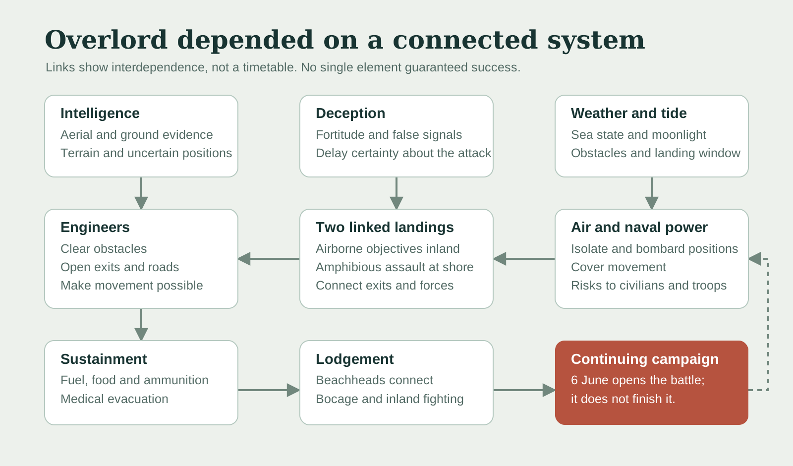
A focused coastal day can connect Omaha Beach, German defensive sites, Pointe du Hoc, the Overlord Museum and Normandy American Cemetery. A wider U.S.-sector journey adds Utah Beach and Sainte-Mère-Église across the Cotentin. The accompanying podcast considers both a long road day from Paris and rail with local guiding from Bayeux; deciding which landscape to cover comes before choosing the transport. A stop list that promises everything deserves a close look at how much time remains at each place.
The distinction matters because D-Day tourism easily becomes a sequence of famous names: beach, bunker, cliff, tank, cross. The military operation was the opposite of a sequence of isolated objects. An aircraft route over the Cotentin affected a causeway behind Utah. A weather forecast affected a fleet at sea. A beach exit affected the movement of artillery, ambulances and fuel. A French rail junction bombed before the landings affected German reinforcement and civilian survival. The cemetery above Omaha holds a national selection of the dead from a campaign whose casualties extended far beyond its boundaries.
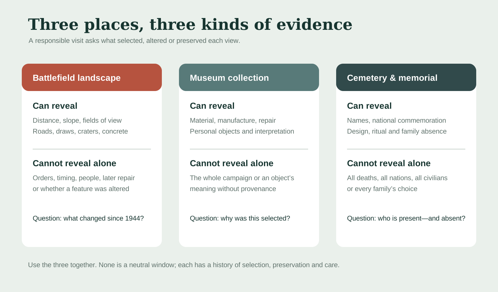
The better question is not “How many D-Day sites can fit into a day?” It is “What relationship becomes visible at each stop?” Omaha explains distance and exposure. Pointe du Hoc tests the gap between plan and battlefield reality. A museum makes machines, personal objects and curatorial selection visible. The cemetery shows how a nation names, arranges and mourns loss. None can stand in for the others.
02 · Normandy battlefield field guide
Before liberation came occupation
The route begins historically long before the first landing craft. German forces occupied northern France from 1940. Daily life was governed by military authority, shortages, requisitions, censorship, forced labor policies, arrests and the threat of collective punishment. The Atlantic Wall was not one continuous wall but a defensive system of strongpoints, guns, obstacles, minefields, radar sites and field works placed according to terrain and available resources. Some concrete positions were formidable; others were incomplete or thinly held. Propaganda made the system look more uniform than it was.
Construction also had a human history. German military engineers, the Organisation Todt, contractors and coerced or forced workers built and expanded coastal defenses. The surviving concrete does not disclose who mixed it, who resisted, who complied under constraint or which planned element remained unfinished. A bunker visit that begins only with caliber and firing arc misses the occupation that made the structure possible.
French resistance networks supplied intelligence, observed movements, helped airmen, sabotaged communications and supported Allied operations. Their work carried the risk of torture, execution and reprisals. Resistance was neither universal nor politically simple. Occupied communities included resisters, collaborators, people trying to survive, refugees, agricultural families and officials making compromised choices. The phrase “liberated village” describes a decisive change in power; it does not erase four years of fear or the destruction that liberation itself could bring.
Allied planners faced an ethical and operational collision. Bombing railways, bridges, roads and towns could slow German reinforcement, yet it could also kill French civilians and destroy the places the invasion intended to free. Air superiority did not make bombs precise in the modern sense. Families in Normandy sheltered from both occupiers and Allied attacks. The French Ministry of the Armed Forces' account of civilian victims places those deaths inside the Battle of Normandy, not outside the “main” military story.
That wider frame changes what a present-day visitor sees. A farm lane can be a reinforcement route, an evacuation route and a family road at once. A ruined town can represent liberation, aerial power and civilian loss. Memory here is not weakened by complexity. It becomes more truthful.
03 · Normandy battlefield field guide
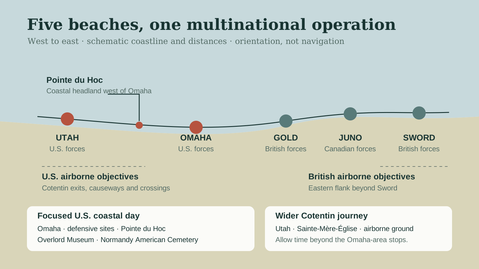
Overlord was a machine made of decisions
Operation Overlord was the Allied campaign to establish a lodgement in Normandy and then advance into occupied Europe. The assault phase, including the cross-Channel naval operation known as Neptune, required armies, navies and air forces to synchronize on a scale that had no forgiving precedent. More than a million personnel and mountains of equipment were staged in Britain. Landing craft, gliders, aircraft, warships, engineers, medical units, communications, fuel, food and replacement troops all had to arrive in a usable order.
The coast was chosen through an argument among constraints. The Pas-de-Calais offered a shorter Channel crossing but heavier defenses and stronger German expectations. Normandy placed the invasion within fighter range, offered beaches that could support landings and gave access to ports and road networks, but it also presented marshes, bluffs, tides, reefs, bocage and the need to build supply capacity before a major port was secure.
Intelligence reduced uncertainty without eliminating it. Aerial reconnaissance mapped defenses and terrain. Resistance reports added observations from the ground. Hydrographic teams studied sand and approaches. Yet a map could not predict the exact landing point of a craft in current and smoke, the effect of bombardment on a particular position, or the decisions made by a small unit after its officers were killed or separated.
Deception created another layer. Operation Fortitude used false formations, controlled radio traffic, double agents, dummy equipment and other signals to reinforce German belief that the main blow would fall in the Pas-de-Calais. The deception did not make Normandy undefended. It helped delay certainty about whether the landings were the main invasion, influencing the release and direction of German reserves.
Weather and tide were not scenery. Planners wanted low enough water to expose obstacles for demolition teams, rising water to carry following waves inland, usable moonlight for airborne navigation and seas calm enough for small craft. British meteorologist James Stagg's forecast helped persuade Dwight D. Eisenhower to postpone the assault from 5 to 6 June. The chosen window was still rough. Seasickness, spray, cloud and wind affected aircraft, landing craft and the people inside them.
Air and naval power isolated and covered the battlefield, but neither was an automatic solution. Bombing could miss or be deliberately released late to avoid hitting approaching troops. Naval guns could suppress or destroy positions, then shift fire as soldiers moved inland. Aircraft attacked transport and reinforcements while also creating risk for civilians and friendly forces. The system worked through overlapping, imperfect effects—not through one decisive technology.
04 · Normandy battlefield field guide
Five beaches, more than three nations
The landing front ran west to east through Utah and Omaha for U.S. forces, Gold for British forces, Juno for Canadian forces and Sword for British forces. Air crews, sailors, soldiers and support personnel came from a much wider Allied coalition. Free French commandos landed in the Sword sector; Polish, Norwegian, Dutch, Belgian, Czech, Greek and other personnel contributed at sea or in the air and across the campaign. Reducing D-Day to an exclusively American operation distorts its scale even when the day's route focuses on American sites.
The beaches also had different operational problems. Utah sat on the eastern Cotentin Peninsula, backed by deliberately flooded lowlands. Airborne forces from the U.S. 82nd and 101st Airborne Divisions were to secure exits, roads, crossings and positions inland so the seaborne force would not be trapped against the water. Strong currents carried the initial landing south of its planned point, but the troops found less concentrated opposition and were able to move through exits whose inland security was crucial.
Omaha presented a longer, more exposed approach to bluffs cut by a small number of draws. German defenses could cover beach obstacles, the tidal flat, shingle and exits. Units were scattered, landing craft were lost or displaced, and the presence of elements of the experienced German 352nd Infantry Division made the defense stronger than some assault planning assumed. The outcome depended on dispersed groups finding ways off the beach, engineers working under fire, naval support brought close to shore and initiative at many levels.
Gold, Juno and Sword had their own strongpoints, obstacles, towns and inland objectives. British and Canadian forces fought through coastal positions and toward routes, airfields and the city of Caen. Some first-day objectives were not reached. The beachheads nevertheless held and began to connect. The story is therefore neither five parallel victories nor five versions of the same beach. It is five distinct assaults designed to create one lodgement. The companion Juno Beach and Canadian-sector field guide follows Courseulles, Bernières and Saint-Aubin inland to the Juno Beach Centre and Bény-sur-Mer cemetery.
05 · Normandy battlefield field guide
The inland battle began before dawn
Hours before the seaborne landings, airborne operations placed U.S. divisions across the Cotentin. Cloud, anti-aircraft fire, navigation errors and evasive action scattered aircraft and paratroopers. Scattering disrupted planned concentration, yet it also produced small groups that attacked objectives or caused uncertainty among defenders. Gliders carried troops and equipment with their own severe landing risks.
The flooded lowlands behind Utah turned causeways and bridges into operational hinges. Holding an exit was not a minor task behind the “real” beach battle; it determined whether vehicles and artillery could leave the shore and whether German forces could counterattack across the same ground. Sainte-Mère-Église became important because roads through the town linked the peninsula. The 82nd Airborne fought to hold it and crossings in the area while the 101st worked toward exits and routes farther south.
One incident became a shorthand for the airborne night. John M. Steele of the 82nd Airborne caught his parachute on the tower of Sainte-Mère-Église's church and survived. The Airborne Museum notes that the later claim that he was made deaf by the bells is a rumour; Steele maintained a relationship with the museum and attended its 1964 opening. The mannequin visible on the church today is a commemoration installed on the opposite side from Steele's actual position so it can be seen from the square.
That distinction is a useful lesson in myth-history. The core incident is documented. A film, a visible mannequin and repeated retelling made it the dominant image of a much larger airborne operation. The symbol helps people remember; it can also compress thousands of scattered landings, deaths, captures and improvised fights into one cinematic silhouette. To follow that history on the ground, give Sainte-Mère-Église and Utah their own Cotentin time. A concentrated Omaha-area route cannot offer the same inland picture simply by mentioning the famous church.
06 · Normandy battlefield field guide
At Omaha, read from water to hedgerow
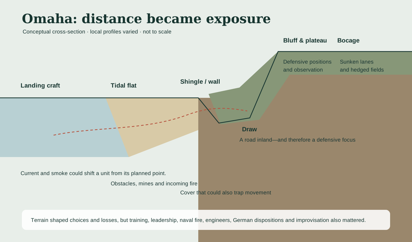
Omaha's name covers a coast several miles long, not one viewpoint. To read it, begin offshore. Landing craft approached through rough water, current and smoke. Some arrived away from their assigned sectors. Men stepped into water of uncertain depth carrying equipment that could become dangerous when soaked. Tanks, artillery and demolition teams did not all arrive where or when plans expected.
At lower water the beach could be a broad tidal surface. Obstacles—wooden ramps, stakes, metal constructions and mines—were intended to damage craft and channel movement. Engineers had limited time to open lanes while under fire and before the tide covered the work. The shingle bank and sea wall offered fragments of cover, but they also concentrated people at the foot of the bluffs.
Beyond lay draws: natural cuts offering roads inland. A draw was both opportunity and target. Defensive positions could cover its approaches, while mines and obstacles could slow vehicles. Between draws, steep slopes and bluffs made movement difficult but not impossible. Small groups climbed where they could, sometimes bypassing the strongest positions and attacking from flanks or rear. Naval destroyers later moved close enough to engage positions with more direct observation. The beach did not suddenly become safe; it became passable in pieces.
The plateau beyond the bluffs was not open relief. Roads entered villages, orchards and fields enclosed by banks and dense hedges—the bocage. Sunken lanes and limited sight lines favored defense and made navigation difficult. The famous beach was therefore the first belt of a landscape that continued to shape the campaign for weeks.
Terrain did not decide the result by itself. Geography interacted with German unit strength and positioning, incomplete Allied intelligence, the accuracy of bombardment, engineering work, equipment loss, training, naval fire, communications and individual decisions. Saying “the bluffs caused the casualties” is as incomplete as saying courage overcame the bluffs. A battlefield is an environment in which institutions and people meet physical constraints.
That way of reading terrain has a useful counterpart in Lexington and Concord. There, a common, bridge, bend, hill and sixteen-mile road reveal how an alarm network turned into dispersed combat; at Omaha, water depth, obstacles, draws, bluffs and hedgerows reveal how an amphibious plan fragmented into local decisions. The wars, political stakes and scale are different. The shared method is to treat landscape as evidence rather than patriotic scenery.
07 · Normandy battlefield field guide
A photograph is a moment, not the whole landing
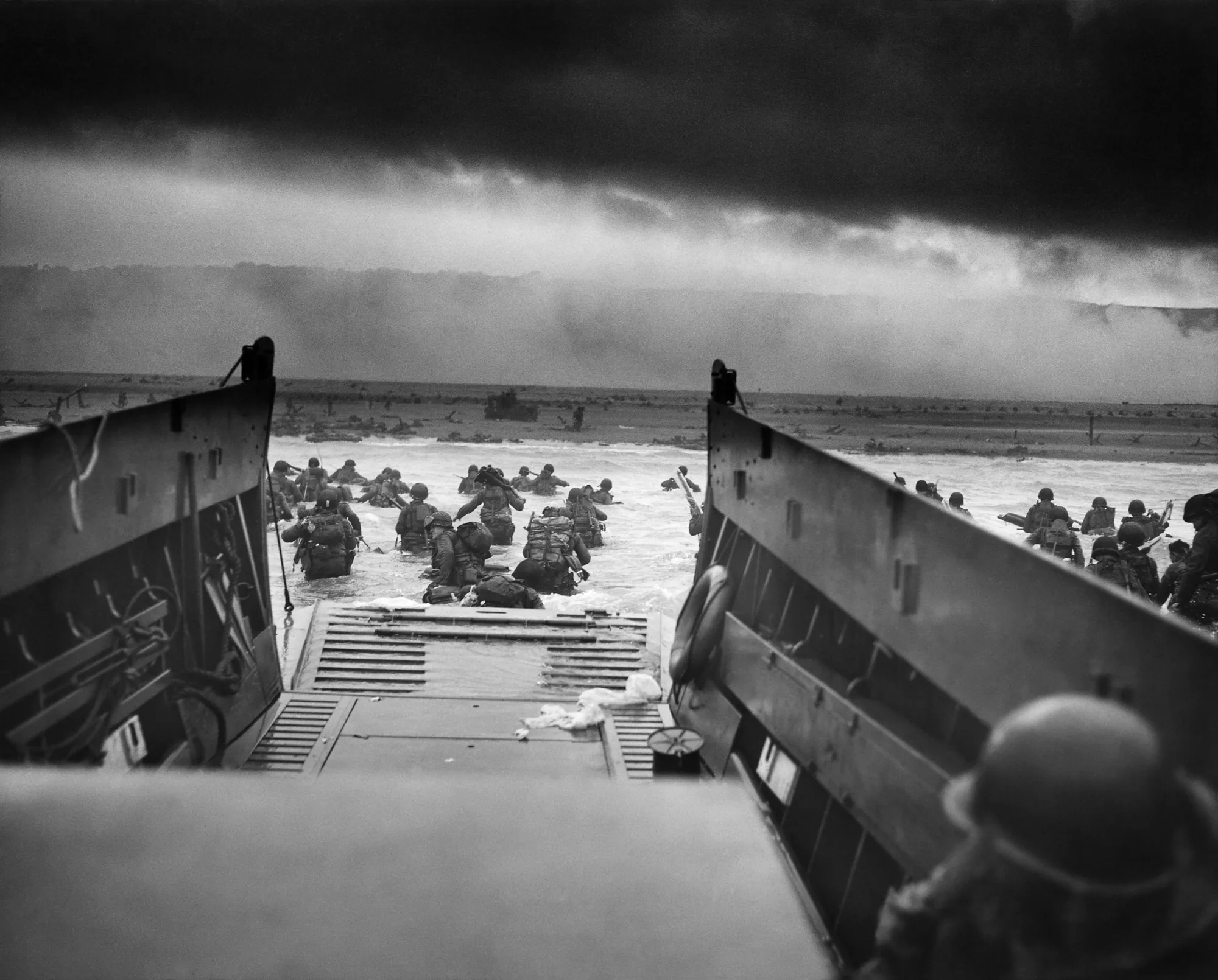
Robert F. Sargent's photograph often titled Into the Jaws of Death shows troops leaving a landing craft for the water at Omaha. It has become one of the most recognized images of D-Day because it places the viewer behind the ramp, looking toward a shore partly obscured by smoke and spray. The men are not anonymous symbols in the original record; they belonged to a particular wave, unit and moment. Yet the image's later circulation detached it from much of that context.
The photograph is powerful evidence of bodily exposure, the awkward transition from craft to water and the limited information visible from a landing ramp. It does not show the full width of Omaha, the defenders' positions, what happened to every person in frame, or the later work of opening exits. It should not be treated as a visual summary of all five beaches or of every landing wave.
This is why archival captions matter. Date, photographer, agency and original description help distinguish a primary record from a film still, a reenactment or a later composite. Cropping can make the ramp feel narrower, remove landmarks or change the relationship between sea and shore. A responsible museum or article identifies the image's origin and uses it for the limited claim it can support.

08 · Normandy battlefield field guide
People cannot be reduced to casualty totals
Military histories need numbers to describe scale, but totals conceal different experiences. A person could be killed before reaching the shore, wounded on the tidal flat, separated from a unit, captured inland, evacuated to a ship, listed missing while records caught up, or buried first in a temporary cemetery. A civilian could die in a bombing intended to slow a German division. A German conscript could defend a position inside a regime of occupation and racial war without that fact making the forces morally equivalent.
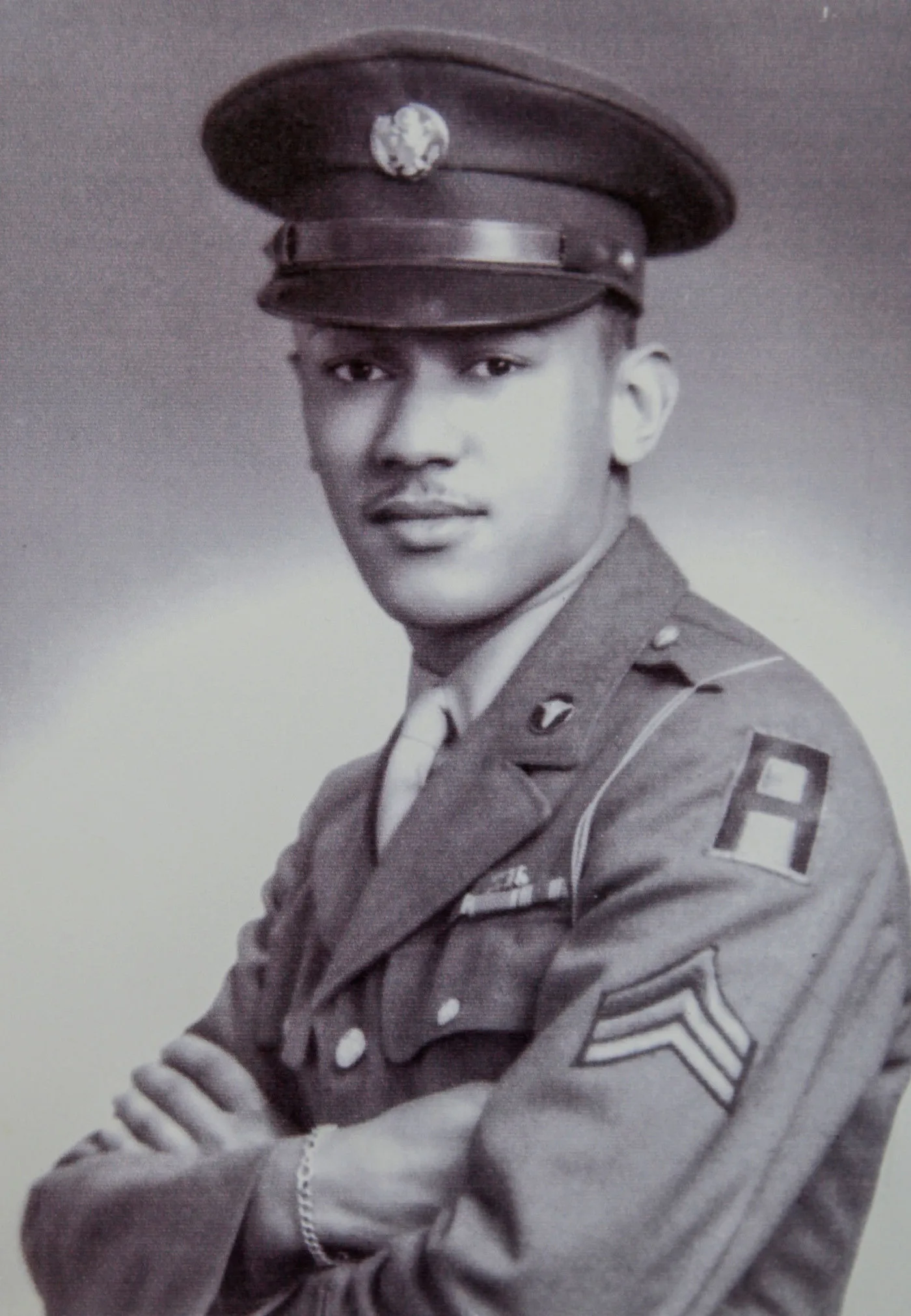
The Allied armies were also unequal institutions. Waverly B. Woodson Jr., a medic with the 320th Barrage Balloon Battalion, treated casualties on Omaha Beach despite being wounded himself. His unit was part of a segregated U.S. Army. Woodson's service complicates an easy story of freedom arriving through an institution that denied equal treatment to many of its own members. In 2024, the U.S. Army awarded him a posthumous Distinguished Service Cross recognizing his actions. The long delay is part of the story of evidence, advocacy and official memory.
Medics and litter bearers worked in exposed conditions with limited supplies. Naval vessels and landing craft became evacuation links. Aid stations moved as beach exits opened. The medical chain did not end suffering, and it did not move in a neat diagram, but it converted the beachhead into a system capable of receiving casualties and returning some to larger facilities across the Channel.
Missing status created another form of loss. A family could receive incomplete or changing information. Bodies recovered later might be identified through tags, records and personal effects; others remained unknown. The Walls of the Missing at Normandy American Cemetery carry names for which no identified grave was available there. A rosette added later can mark a person whose remains were recovered and identified. That small change turns stone into a record that can still be revised.
German dead are buried in separate cemeteries managed through different national and institutional traditions. British, Canadian, Polish and other Allied dead lie in cemeteries across Normandy. French civilians are commemorated in municipal records, memorials and local memory, but not gathered into one landscape equivalent to the American cemetery. No single stop contains the campaign's complete human cost.

09 · Normandy battlefield field guide
Logistics turned landings into a lodgement
Getting ashore was not enough. A force that could not move fuel, ammunition, food, vehicles, communications equipment and replacements inland would remain vulnerable. Engineers cleared obstacles, marked lanes, repaired roads and built exits. Military police organized traffic. Signal units established communications. Beach groups sorted cargo that did not always arrive in planned order.
The Allies brought prefabricated artificial-harbour components across the Channel. Mulberry B at Arromanches, in the British sector, became an important supply facility. The American Mulberry off Omaha was badly damaged by the severe storm that began on 19 June and was not restored as a complete harbour. Supplies nevertheless continued across open beaches and through smaller ports while Cherbourg was captured and repaired. The episode is a warning against treating engineering as a guaranteed workaround: design, weather, maintenance and improvisation all mattered.
Utah and Omaha beachheads linked with forces inland as units pushed toward Carentan and across the Cotentin. In the east, British and Canadian forces faced hard fighting around Caen. German counterattacks, destroyed bridges, civilian movement and congested roads complicated every advance. The lodgement expanded, but the bocage campaign imposed high costs and slow progress.
The phrase “D-Day sites” can make 6 June feel self-contained. It was the first day of a campaign. The Battle of Normandy continued through the summer, destroying towns and displacing civilians before Allied forces broke out. A return to Paris on the evening of a tour closes a visitor's itinerary, not the history.
10 · Normandy battlefield field guide
Pointe du Hoc: the guns were not in completed casemates
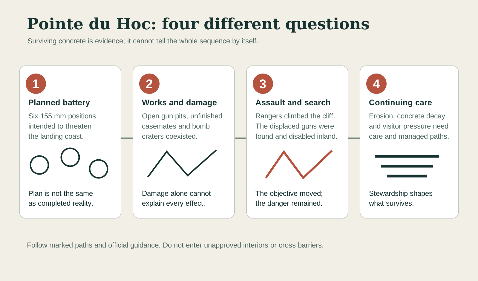
Pointe du Hoc projects into the Channel between Utah and Omaha. Its height and position made a planned German battery there an important Allied concern. The familiar simplified version says that Rangers scaled the cliffs to destroy six 155 mm guns in concrete bunkers. The actual sequence is more instructive.
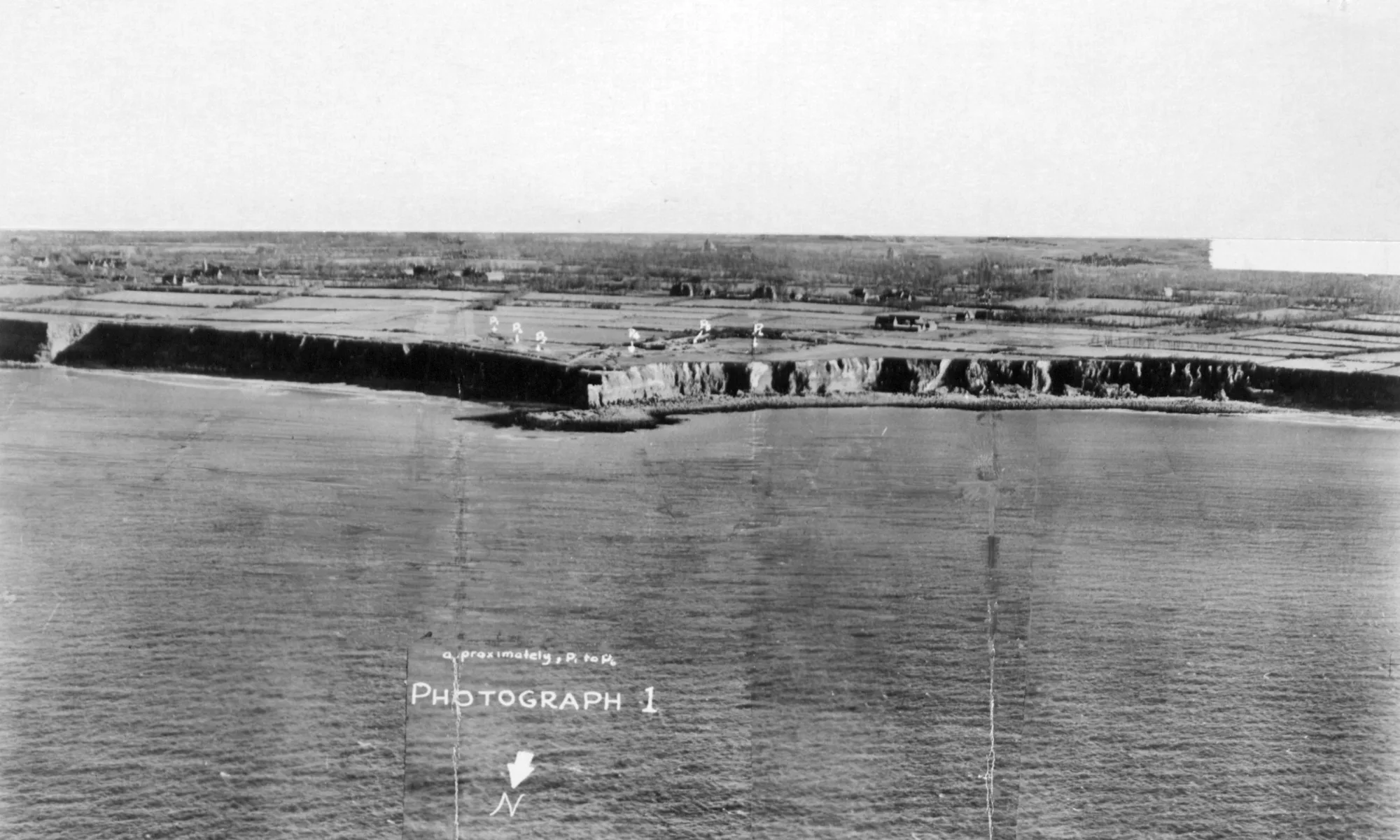
German works included open gun pits and casemates that were incomplete when the assault came. Aerial photography and bombardment recorded a changing site. The guns had been moved away from the point before 6 June. The 2nd Ranger Battalion, commanded by Lieutenant Colonel James Rudder, still had to climb the cliffs under fire, fight across a cratered position and determine that the primary weapons were absent. Patrols then found the guns inland and disabled them. German counterattacks and isolation inflicted severe losses before relief.
The assault was therefore not pointless because the guns were displaced, nor was it the destruction of a neat battery exactly as drawn in planning diagrams. It was a mission conducted against uncertain, changing evidence. The Rangers had to convert “objective not where expected” into a search and denial task while holding difficult ground.
The 1943 aerial photograph is especially useful because it shows the point before the heaviest bombardment and before later conservation. Open positions are visible in the fields. It should be read beside later aerials and ground plans; on its own, it does not identify which gun was present on which date or what a crater was intended to hit.

11 · Normandy battlefield field guide
The battlefield is moving under visitors' feet
Pointe du Hoc looks raw because bomb and shell craters, damaged concrete and the cliff edge remain legible. That appearance is not the same as an untouched battlefield. The sea erodes the headland. Rain, salt, vegetation and freeze-thaw cycles affect concrete. Visitor feet compact soil and widen paths. Safety work, archaeological investigation and stabilization change access in order to preserve what remains.
Access is part of that stewardship, not an entitlement to every crater, path or bunker interior. The competent authority may route people away from vulnerable fabric while archaeological or safety work is under way. The durable decision is to assume uneven ground, follow the marked public route and treat any interior access as unavailable unless the official planning page says otherwise near the date of the visit.
Stay on marked paths. Craters create uneven ground, and concrete can be unstable. Boundaries protect both people and evidence. A photograph taken beyond a barrier is not worth damage to the place or disruption of conservation work. Visitors with limited mobility should use the live ABMC planning page rather than rely on an old review or map.
12 · Normandy battlefield field guide
A museum makes choices visible
The Overlord Museum near Colleville-sur-Mer offers a different evidence environment. Its collection grew from the work of Michel Leloup; the museum describes some 10,000 items, including around forty vehicles, tanks and guns. Large machinery gives visitors an immediate sense of scale, weight and material. A tank track, radio or medical object can make the logistical system tangible in a way a distant beach cannot.
The museum’s collection history gives that machinery a revealing afterlife. Leloup, born in 1929, grew up on a farm near L’Aigle and witnessed war as a teenager. The museum describes a German Panzer IV generator driving the saw and a Canadian Chevrolet truck carrying wood. In the early 1970s he recognized another wartime vehicle in a sawmill wreck and restored it, beginning the collection that later developed with his son Nicolas. Salvage, reuse and recovery came before museum display. That sequence helps explain why an object may survive: it had a civilian job after its military one, then acquired a new purpose as evidence. Leloup died in 2011 before the present museum opened.
But objects do not interpret themselves. A restored vehicle may combine original material with replacement parts. A uniform can represent one person or be assembled to illustrate a type. A diorama compresses space, selects a moment and directs attention. Lighting, sound and sequencing influence emotion. Labels and provenance determine whether an object supports a precise claim or merely creates atmosphere.
The useful museum questions are practical: Who used this object? Where did it come from? How much has been restored? Why is it placed beside these other things? Does a reconstruction distinguish documented configuration from illustration? A collection can show material culture, manufacturing, maintenance and personal possession. It cannot by itself explain an entire operation or guarantee that every displayed object was at the exact stop visited outside.
Time matters here. The museum advises allowing roughly 60 to 90 minutes, while a group route may allocate less. If vehicles, personal histories or curatorial method are a priority, ask how long the museum stop lasts before choosing a format and check the museum's own planning page near departure. “Museum entry” and “time to read a museum” are not the same inclusion.
13 · Normandy battlefield field guide
The cemetery is architecture, policy and private grief
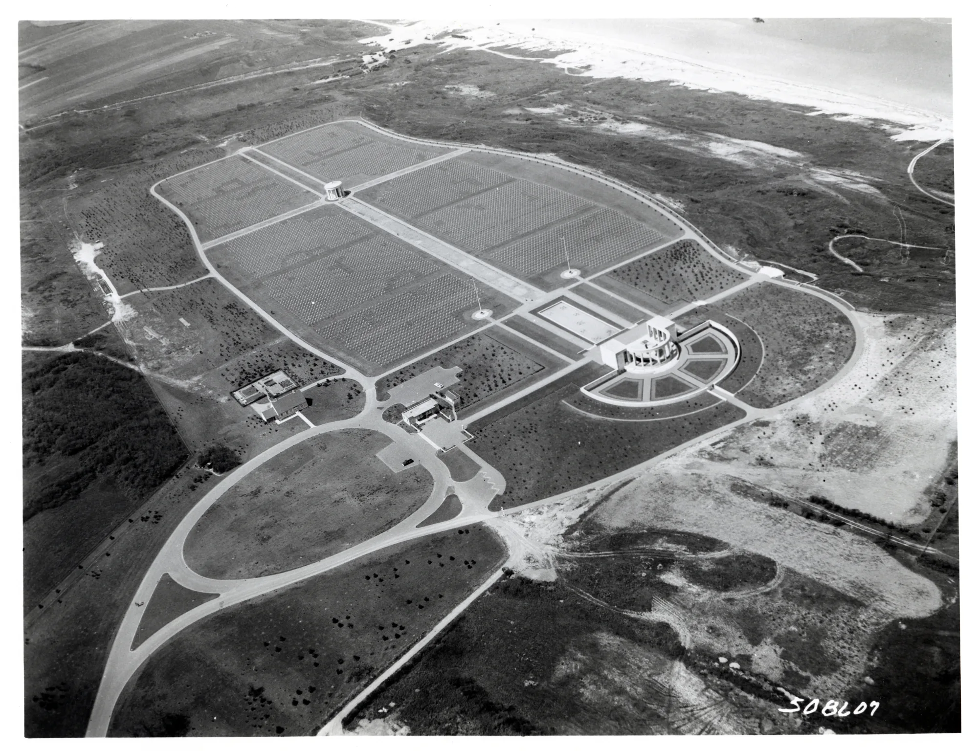
Normandy American Cemetery occupies 172.5 acres above Omaha Beach. It contains 9,389 graves. The Walls of the Missing bear 1,557 names. The first temporary American cemetery at Saint-Laurent was established on 8 June 1944; the permanent cemetery later consolidated graves from ten temporary cemeteries. Families made decisions about whether remains would stay overseas or be repatriated to the United States.
The rows of white markers create visual equality at a distance, but details resist abstraction. Most are Latin crosses; others are Stars of David. Rank does not organize the burial fields. The ABMC cemetery booklet records 306 headstones of unknown soldiers, four women and three Medal of Honor recipients. It also records forty-five sets of brothers commemorated or buried here, with thirty-three sets buried side by side. Those numbers should lead back to names and relationships, not become a trivia list.
Dedicated on 18 July 1956, the permanent cemetery brought together memorial buildings by Harbeson, Hough, Livingston and Larson, landscape design by Markley Stevenson and sculpture by Donald de Lue. The memorial’s semicircular colonnade contains maps explaining the operations. A reflecting pool, de Lue’s Spirit of American Youth Rising from the Waves statue and a chapel establish a designed progression. The visitor center and landscape architecture lead from campaign orientation toward individual service and death. Hedgerow references and material choices connect the modern complex to Normandy without pretending the cemetery is a preserved combat position.
Pearl Harbor and historic Honolulu offer a revealing contrast in American war memory. Normandy arranges graves, missing names, campaign maps and a coastal prospect into a national cemetery; at Pearl Harbor, a memorial spans a wreck that remains a tomb, while Honolulu's royal, civic and military sites place the attack inside a longer Hawaiian history. Reading the two together shows why a memorial's architecture cannot substitute for the landscape, institutions and people around it.
This choreography can produce strong emotion, but an article cannot prescribe what anyone must feel. A veteran's family, a school group, a local resident and a first-time tourist may inhabit the same space differently. Some people seek a specific name. Others are learning the scale for the first time. Quiet is a form of shared access, not proof of one approved response.
Flag lowering follows the cemetery's operating day rather than one fixed clock time throughout the year. Check the official planning page for current hours, last admission, ceremony timing and the permitted relationship between cemetery and beach access. Do not plan a shortcut because an old blog or podcast describes one.

14 · Normandy battlefield field guide
Memory continued after the armies moved on
Temporary cemeteries made death visible to nearby communities immediately after the landings. Norman residents tended graves, placed flowers and corresponded with families overseas. Reconstruction, agriculture and commemoration occurred on the same land. Some families rebuilt houses beside damaged defenses; others left ruins or donated ground for memorials. Anniversary ceremonies developed while survivors and witnesses were still alive.
Film and tourism then changed the geography of attention. Certain incidents and sites became internationally famous while others remained local. Sainte-Mère-Église's mannequin, the Pointe du Hoc craters and Omaha's cemetery rows became recognizable images. That visibility supports preservation and local livelihoods, yet it can also create expectations of permanent access, pristine relics or a single patriotic story.
Present-day Normandy is not a museum campus. People live, farm, commute and raise children among memorials and remnants. Beaches are recreational and ecological spaces as well as battlefields. Land ownership varies. A bunker on private land is not an invitation to trespass. A fragment found in a field is not automatically a souvenir.
Unexploded ordnance remains a real hazard. The Calvados authorities instruct anyone who discovers suspected wartime ammunition not to approach, touch or move it and to report it to police or gendarmerie on 17, or to the mairie. Keep clear and describe the location from a safe distance; do not try to clean, collect or make the object safe. Metal collecting damages archaeological context even when an object is not dangerous. A rusted piece removed from the ground loses its location, association and potential meaning; it may also be lethal.
Conservation therefore involves choices about erosion, access, archaeological context, vegetation and visitor pressure. Preserving every concrete surface exactly as it stood is impossible. The responsible question is which evidence can be stabilized, documented and interpreted without creating new danger or pretending decay has stopped.
15 · Normandy battlefield field guide
Conduct is part of the visit
At a battlefield, stay on paths, respect marked boundaries and do not climb structures. At a museum, follow photography rules and do not touch objects unless the display explicitly invites it. At the cemetery, ABMC visitor guidance permits respectful personal photography and excludes non-commemorative influencer or promotional activity; commercial filming requires advance permission. Tripods, staged poses, flags used as props and repeated takes can intrude on other visitors even when a single photograph would be acceptable.
Do not attach objects to headstones or memorials. Do not sit or lean on markers. Water is permitted; food belongs outside burial areas. Smoking and vaping are prohibited. A flower or small tribute may have personal meaning, but it should comply with staff guidance and never displace or damage an existing item. If a ceremony is underway, give it space and follow staff instructions.
Children do not need to be kept ignorant of the place, but they benefit from preparation. Explain before arrival that the cemetery is both a public historic site and a place where families may grieve. Build in food and toilet stops so basic discomfort does not become the dominant experience. A child who needs a break is not failing a moral test.
Noise and pace matter across the route. A guide may need to keep a group together, but a schedule should still allow brief private attention. Avoid reenactment gestures, weapon poses or comic photographs around graves and memorials. At a beach, remember that bathers and local residents are not disrespecting history simply by living in a landscape that also carries it.
The most useful conduct rule is to ask what your action takes from other people or from the evidence. If it blocks a path, stages someone else's grave, crosses a marked boundary, removes an object or turns private grief into content, do something else.
16 · Normandy battlefield field guide
Four formats place responsibility differently
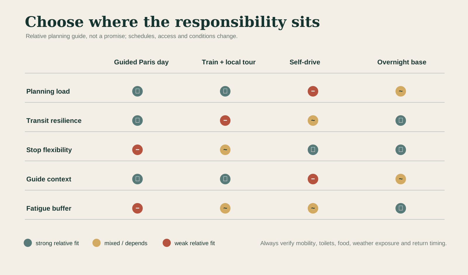
A guided same-day route from Paris places most transport and sequencing responsibility with the operator. It is a strong fit for travelers who want a coherent U.S.-sector introduction, do not want to drive and accept that a very long travel day limits stop depth. The long road journey can support context if guiding begins en route; it can also create fatigue before the most demanding sites. Confirm the meeting point, vehicle, toilet plan, meals and return range rather than assuming a hotel pickup or fixed arrival time.
Train from Paris Saint-Lazare to Bayeux plus a local tour replaces road time with rail and may place the guide closer to the sites. Allow several hours for each rail journey, plus the transfer between Bayeux station and the local departure point. Check the actual date: not every service is direct, and the earliest useful arrival may be later than a local tour’s departure. The vulnerability is the connection: an early local departure may not meet the first practical train, and an evening delay can threaten the return. The ABMC itself warns that local transport is intermittent. Book the rail and ground plan as one chain, not two optimistic reservations.
Self-drive offers the most control over sequence, weather pauses and less famous sites. It also assigns navigation, parking, official access checks and all driving fatigue to the traveler. Narrow lanes, agricultural traffic and emotionally demanding stops can make a dense plan unsafe. A designated driver who is also trying to interpret the landscape has two jobs. Avoid building a route that requires rushing between sites.
An overnight base in Bayeux or elsewhere in Normandy creates the largest fatigue buffer. It allows a museum to receive real time, weather to change without collapsing the day and the U.S. sector to be separated from British and Canadian sites if desired. It costs another night and transfers more planning responsibility to the traveler, but it is often the only format that can hold both wide campaign context and close attention without padding a single day.
If the wider trip also includes Mont-Saint-Michel, treat it as another complete Normandy landscape rather than an extra silhouette squeezed into the battlefield day. The mount becomes legible through granite, tide, monastic construction, village, dam and bridge; the D-Day coast through occupation, terrain, operations and commemoration. Both reward the same discipline—follow the relationships that make a famous view—but each needs its own time and sources.
Mobility can reverse the apparent hierarchy. Cratered paths at Pointe du Hoc, long cemetery distances, vehicle steps and beach gradients require specific checks. A private vehicle may offer flexibility but not accessible interpretation. A guided vehicle may reduce walking between places but still include uneven ground. Ask for the exact walking surfaces and alternatives, not a generic “accessible” label.
Emotional pacing is also practical. Put food and toilets before they become urgent. Avoid treating the cemetery as the automatic climax for every traveler. Some people prefer the museum before the battlefield; others need objects after the open landscape. There is no universally correct emotional arc.
17 · Normandy battlefield field guide
Plan the living coast, not a film set
Begin with the places you want to understand and reserve enough time to move between them. Build the selected-date plan using the ABMC Normandy cemetery page, the ABMC Pointe du Hoc planning page, the Overlord Museum's visitor page and SNCF's selected-date timetable.
Check the coast's weather rather than Paris alone, protect enough time for the museum or memorial that matters most, and treat rail, local transport and the return journey as one chain. For a guided departure, confirm the meeting location, the named stops, time at each site, vehicle boarding, walking surfaces and return arrangements before booking. An itinerary that includes a place still needs enough time for you to read it.
Leave room for a meal, wind or rain, a longer explanation and a quiet pause. A realistic day connects the history while allowing attention to survive the journey.
18 · Normandy battlefield field guide
Listen: Normandy’s U.S. sector
The accompanying episode of The Travel Podcast by ExcursionPass compares the road journey from Paris with rail to Bayeux and local guiding. It raises a useful question to carry into planning: how much of the day is transport, and how much is time to understand the places themselves?
Listen for the relationship between guide, landscape and sequence. A guide’s map or archival photograph can locate a defensive position that is hard to recognize in grass and concrete. At Omaha, look from the water toward the exits; at Pointe du Hoc, ask how the mission changed when the guns were absent. The museum and cemetery then offer different kinds of evidence, rather than two interchangeable indoor or memorial stops.
19 · Normandy battlefield field guide
The return to Paris should not close the story
By evening, the road east can make the coast feel complete: famous places visited, photographs made, a long day finished. The history resists that closure. Airborne troops were still fighting for crossings. Beach exits had to carry an expanding army. Engineers and medical units kept the lodgement alive. Civilians were still being killed and displaced. The bocage, Caen, Cherbourg and the Falaise fighting lay ahead.
The present landscape also remains unfinished. A name on a wall can acquire a rosette after identification. A headland’s concrete is stabilized and its paths managed. A museum revises a label. A family returns with information. A farmer reports ammunition. A town changes how it commemorates a cinematic story.
That is why the U.S. sector is best understood as a connected cultural landscape rather than a row of attractions. The beach gives the body scale. The cliff gives uncertainty a shape. The museum exposes selection. The cemetery gives national memory an architecture. Roads, villages and fields hold the civilian and logistical systems between them.
A responsible visit does not require one approved feeling. It requires attention: to what the route includes, to what a source can prove, to who is missing from the frame, and to the people who continue to live with the landscape after the visitors return to Paris.